IMAGES TAKEN NEAR TO
Barton Lane, NOTTINGHAM, NG11 0AB
Introduction
This page details the photographs taken nearby to Barton Lane, NG11 0AB by members of the Geograph project.
The Geograph project started in 2005 with the aim of publishing, organising and preserving representative images for every square kilometre of Great Britain, Ireland and the Isle of Man.

There are currently over 7.5m images from over14,400 individuals and you can help contribute to the project by visiting https://www.geograph.org.uk
Image Map
Images are licensed for reuse under creativecommons.org/licenses/by-sa/2.0
Notes
- Clicking on the map will re-center to the selected point.
- The higher the marker number, the further away the image location is from the centre of the postcode.
Image Listing (42 Images Found)
Images are licensed for reuse under creativecommons.org/licenses/by-sa/2.0
Image
Details
Distance
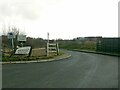
2
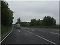
Green Street at New Road
Formerly the A453, looking towards Nottingham. Barton Lane used to branch to the right where I am standing, but has been realigned to pass under the new A453 and also reduced to the status of private road with public bridleway rights.
Image: © Alan Murray-Rust
Taken: 1 Mar 2023
0.03 miles
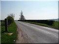
4
Barton Lodge
The A453 is crossed by the old road between Gotham and Barton-in-Fabis.
Image: © Alan Murray-Rust
Taken: 30 May 2010
0.04 miles
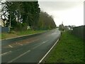
5
Barton Lane
The junction with Green Street, with the A453 in the background. The notice indicates access arrangements.
Image: © Alan Murray-Rust
Taken: 1 Mar 2023
0.04 miles
6
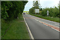
Green Street
The old name of what was once simply a country lane, completely transformed by being rebuilt as the main link south from Nottingham to the M1, now the A453.
Image: © Alan Murray-Rust
Taken: 30 May 2010
0.05 miles
7
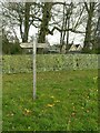
Fingerpost at Barton Lodge
This relates to the bridleway route between Barton and Gotham. Since the A453 was improved, and Barton Lane reduced to bridleway status, the vehicle route between here and Gotham has increased to 4.5 miles! In the background, a new wing is being added to Barton Lodge to replace one that was demolished in the mid 20th century.
Image: © Alan Murray-Rust
Taken: 1 Mar 2023
0.05 miles
8
Green Street at New Road
Formerly the A453. In those days it would have been madness to take a picture from this precise point, as the traffic visible on the new road testifies.
Image: © Alan Murray-Rust
Taken: 1 Mar 2023
0.07 miles
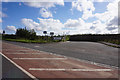
9
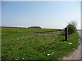
Open countryside, off Barton Lane
With incomplete hedges and no fences, it would be difficult to keep livestock on this grassland.
Image: © Christine Johnstone
Taken: 17 Apr 2010
0.07 miles
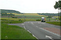
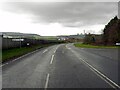
10
Barton Lane
Heading from the junction with Green Street towards the Nottingham Road.
Image: © Christine Johnstone
Taken: 17 Apr 2010
0.07 miles