IMAGES TAKEN NEAR TO
Waterside Close, NOTTINGHAM, NG10 5PW
Introduction
This page details the photographs taken nearby to Waterside Close, NG10 5PW by members of the Geograph project.
The Geograph project started in 2005 with the aim of publishing, organising and preserving representative images for every square kilometre of Great Britain, Ireland and the Isle of Man.

There are currently over 7.5m images from over14,400 individuals and you can help contribute to the project by visiting https://www.geograph.org.uk
Image Map
Images are licensed for reuse under creativecommons.org/licenses/by-sa/2.0
Notes
- Clicking on the map will re-center to the selected point.
- The higher the marker number, the further away the image location is from the centre of the postcode.
Image Listing (60 Images Found)
Images are licensed for reuse under creativecommons.org/licenses/by-sa/2.0
Image
Details
Distance
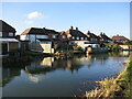
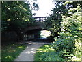
1
Canal Bridge on Longmoor Road
Now passes over a footpath which follows the line of the Derby and Sandiacre Canal.
Image: © David Lally
Taken: 7 Jul 2008
0.05 miles
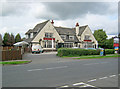
2
The Bridge Inn
On Longmoor Road, just inside the bounds of Sandiacre.
Image: © David Lally
Taken: 15 Mar 2010
0.06 miles
3
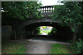
Canal Bridge over Longmoor Road
Looking along the line of the now invisible Derby and Sandiacre Canal.
Image: © David Lally
Taken: 7 Jul 2008
0.07 miles
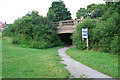
4
Bridge Over the Derby and Sandiacre Canal
This bridge carries Longmoor Lane over a section of the canal which is now a cycle and footpath. The canal has disappeared completely the other side of the bridge.
Image: © Oxymoron
Taken: 21 Jul 2008
0.07 miles
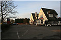
5
The Bridge Inn
Large public house situated on the west side of Longmoor Lane.
Image: © Trevor Rickard
Taken: 18 Sep 2010
0.08 miles
6

Sandringham Road as dawn approaches
The bridge that carries Longmoor Road over the course of the Derby and Sandiacre Canal is on the right.
Image: © David Lally
Taken: 29 Nov 2010
0.09 miles
7
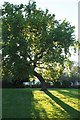
Bent oak tree
Unusual shape, though it does bend to the south.
Image: © David Lally
Taken: 2 May 2020
0.09 miles
8
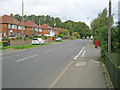
B6002 Longmoor Lane
Major thoroughfare running north at Springfield Park. Typical 1930s-style semi-detached houses on the left.
Image: © Trevor Rickard
Taken: 18 Sep 2010
0.11 miles
9
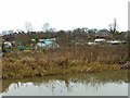
Allotments, Long Eaton
Alongside the Erewash Canal.
Image: © Alan Murray-Rust
Taken: 1 Jan 2018
0.14 miles