IMAGES TAKEN NEAR TO
Collin Avenue, NOTTINGHAM, NG10 5JR
Introduction
This page details the photographs taken nearby to Collin Avenue, NG10 5JR by members of the Geograph project.
The Geograph project started in 2005 with the aim of publishing, organising and preserving representative images for every square kilometre of Great Britain, Ireland and the Isle of Man.

There are currently over 7.5m images from over14,400 individuals and you can help contribute to the project by visiting https://www.geograph.org.uk
Image Map
Images are licensed for reuse under creativecommons.org/licenses/by-sa/2.0
Notes
- Clicking on the map will re-center to the selected point.
- The higher the marker number, the further away the image location is from the centre of the postcode.
Image Listing (100 Images Found)
Images are licensed for reuse under creativecommons.org/licenses/by-sa/2.0
Image
Details
Distance
1
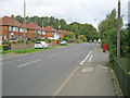
B6002 Longmoor Lane
Major thoroughfare running north at Springfield Park. Typical 1930s-style semi-detached houses on the left.
Image: © Trevor Rickard
Taken: 18 Sep 2010
0.08 miles
2
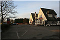
The Bridge Inn
On Longmoor Road, just inside the bounds of Sandiacre.
Image: © David Lally
Taken: 15 Mar 2010
0.11 miles
3
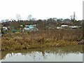
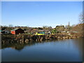
Allotments, Long Eaton
Alongside the Erewash Canal.
Image: © Alan Murray-Rust
Taken: 1 Jan 2018
0.11 miles
4
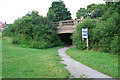
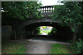
Canal Bridge on Longmoor Road
Now passes over a footpath which follows the line of the Derby and Sandiacre Canal.
Image: © David Lally
Taken: 7 Jul 2008
0.11 miles
5
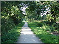
Part of the Derby and Sandiacre Canal
Most of this canal has disappeared, including this section immediately after the junction of the canal with the Erewash canal [http://www.geograph.org.uk/photo/891877]. This short stretch has been filled in and is now a cycle and footpath leading down to Longmoor Lane, about 0.5 km away. The other side of Longmoor Lane the canal has disappeared completely under an housing estate.
Image: © Oxymoron
Taken: 21 Jul 2008
0.12 miles
6
Allotments beyond the canal
Looking across the Erewash Canal.
Image: © Jonathan Thacker
Taken: 26 Jan 2022
0.12 miles
7
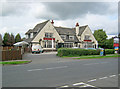
The Bridge Inn
Large public house situated on the west side of Longmoor Lane.
Image: © Trevor Rickard
Taken: 18 Sep 2010
0.12 miles
8
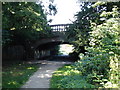
Bridge Over the Derby and Sandiacre Canal
This bridge carries Longmoor Lane over a section of the canal which is now a cycle and footpath. The canal has disappeared completely the other side of the bridge.
Image: © Oxymoron
Taken: 21 Jul 2008
0.13 miles
9
Canal Bridge over Longmoor Road
Looking along the line of the now invisible Derby and Sandiacre Canal.
Image: © David Lally
Taken: 7 Jul 2008
0.13 miles
10
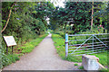
Path of Derby and Sandiacre Canal
Behind is the stub from the Erewash Canal which still contains water. Forward about 200 yards ahead is a rise in the path which looks like it marks where there was a lock (a rise of about 4 feet), then the next feature is the bridge where the canal passed under Longmoor Road Image
Image: © David Lally
Taken: 7 Jul 2008
0.14 miles