IMAGES TAKEN NEAR TO
Derby Road, NOTTINGHAM, NG10 5HS
Introduction
This page details the photographs taken nearby to Derby Road, NG10 5HS by members of the Geograph project.
The Geograph project started in 2005 with the aim of publishing, organising and preserving representative images for every square kilometre of Great Britain, Ireland and the Isle of Man.

There are currently over 7.5m images from over14,400 individuals and you can help contribute to the project by visiting https://www.geograph.org.uk
Image Map
Images are licensed for reuse under creativecommons.org/licenses/by-sa/2.0
Notes
- Clicking on the map will re-center to the selected point.
- The higher the marker number, the further away the image location is from the centre of the postcode.
Image Listing (117 Images Found)
Images are licensed for reuse under creativecommons.org/licenses/by-sa/2.0
Image
Details
Distance
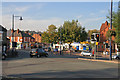
1
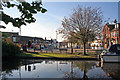
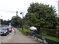
Town Centre, Sandiacre from Erewash Canal
The inn on the right is The Red Lion.
On the left, out of view, is the road bridge with traffic lights. The road ahead was once the A52 before the bypass was built. This is now the B5010.
The grassy area is part of Padmore Moorings where, in 1813, there were lime kilns to produce lime for farms.
Image: © David Pinney
Taken: 21 Oct 2007
0.03 miles
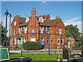
2
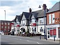
The White Lion
There has been a White Lion here since at least the 19th century but this one replaced an earlier building some time in the 1920s or 30s.
Image: © Ian Calderwood
Taken: 2 Apr 2017
0.03 miles
3
Red Lion, Sandiacre
In those days beer was £1.20 a pint.
Image: © Tim Glover
Taken: 17 Jan 1999
0.03 miles
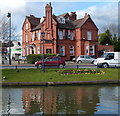
4
The Red Lion, Sandiacre, Nottingham.
Viewed from the Erewash Canal towpath, known as Padmore Moorings, on a beautiful May Sunday morning.
Image: © Patrick A Griffin
Taken: 15 May 2005
0.03 miles
5
Town Centre, Sandiacre from the bridge over the canal
In 1268, King Henry III granted permission for a weekly market to take place here. There was also an annual fair that lasted for 8 days. The white building left of centre by the postbox is the small post office. The Co-op supermarket is behind the trees. The Red Lion pub is on the right. The road ahead is now the B5010 (formerly A52).
Image: © David Pinney
Taken: 21 Oct 2007
0.03 miles
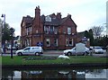
6
Red Lion in Sandiacre
Public house on Town Street, next to the Erewash Canal.
Image: © Mat Fascione
Taken: 28 Feb 2016
0.03 miles
7
The Red Lion, Sandiacre
Seen from across the Erewash Canal with two white swans
Image: © Alan Murray-Rust
Taken: 11 Nov 2007
0.04 miles
8
The Red Lion
Looking west across the Erewash Canal and Town Street.
Image: © Trevor Rickard
Taken: 18 Sep 2010
0.04 miles
9
Town Street and Erewash Canal, Sandiacre
Looking north from Station Road along Town Street (left) and the Erewash Canal.
Image: © Richard Vince
Taken: 7 Jul 2012
0.04 miles
10
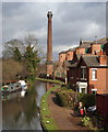
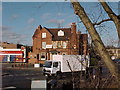
Springfield Mills, Sandiacre, Derbys.
The houses on the right are sandwiched between Bridge Street and the Erewash Canal towpath and in the distance is the former Springfield Mill. The mill was built in 1888 as a tenanted lace factory, for Terah Hooley a wealthy local industrialist, by the architect John Sheldon of Long Eaton.
Image: © David Hallam-Jones
Taken: 14 Feb 2013
0.05 miles