IMAGES TAKEN NEAR TO
Friesland Drive, NOTTINGHAM, NG10 5HP
Introduction
This page details the photographs taken nearby to Friesland Drive, NG10 5HP by members of the Geograph project.
The Geograph project started in 2005 with the aim of publishing, organising and preserving representative images for every square kilometre of Great Britain, Ireland and the Isle of Man.

There are currently over 7.5m images from over14,400 individuals and you can help contribute to the project by visiting https://www.geograph.org.uk
Image Map
Images are licensed for reuse under creativecommons.org/licenses/by-sa/2.0
Notes
- Clicking on the map will re-center to the selected point.
- The higher the marker number, the further away the image location is from the centre of the postcode.
Image Listing (14 Images Found)
Images are licensed for reuse under creativecommons.org/licenses/by-sa/2.0
Image
Details
Distance
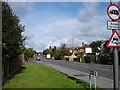
1
Nursery Avenue, Risley
Seen from its junction with Derby Road.
Image: © Richard Vince
Taken: 7 Jul 2012
0.07 miles
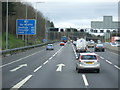
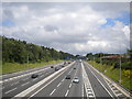
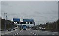
2
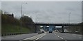
Erewash : M1 Motorway
The M1 Motorway between Junction 25 (Sandiacre) and Junction 26 (Nuthall).
Image: © Lewis Clarke
Taken: 30 Sep 2018
0.09 miles
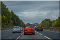
3
M1 near Sandiacre
The M1, looking north from Derby Road, as it passes Sandiacre (right).
Image: © Richard Vince
Taken: 7 Jul 2012
0.10 miles
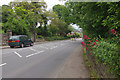
5
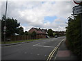
Rushy Lane, Risley
Looking along Rushy Lane towards Stanton-by-Dale from its junction with Derby Road in Risley.
Image: © Richard Vince
Taken: 7 Jul 2012
0.15 miles
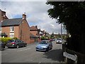
7
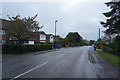
Recycling day on Rushy Lane
Rushy Lane is on the edge of Sandiacre, which in turn is next to Stapleford all part of the Nottingham conurbation. It is obviously bin day for garden waste -the brown bins, and also paper and plastics - the blue bins, which have been put out for collection.
Image: © Malcolm Neal
Taken: 15 Oct 2019
0.16 miles
9
Derby Road, Sandiacre
Looking down the hill towards the centre of Sandiacre. This is now the B5010 but was once the A52, the principal route between Nottingham and Derby. For very many years Sandiacre has been by-passed by the modern A52 to the south.
Image: © Stephen McKay
Taken: 26 May 2014
0.20 miles