IMAGES TAKEN NEAR TO
Lincoln Avenue, NOTTINGHAM, NG10 5GZ
Introduction
This page details the photographs taken nearby to Lincoln Avenue, NG10 5GZ by members of the Geograph project.
The Geograph project started in 2005 with the aim of publishing, organising and preserving representative images for every square kilometre of Great Britain, Ireland and the Isle of Man.

There are currently over 7.5m images from over14,400 individuals and you can help contribute to the project by visiting https://www.geograph.org.uk
Image Map
Images are licensed for reuse under creativecommons.org/licenses/by-sa/2.0
Notes
- Clicking on the map will re-center to the selected point.
- The higher the marker number, the further away the image location is from the centre of the postcode.
Image Listing (17 Images Found)
Images are licensed for reuse under creativecommons.org/licenses/by-sa/2.0
Image
Details
Distance
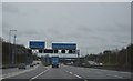
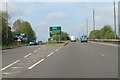
3
Sandiacre : Sandiacre Interchange
On the roundabout between the M1 Motorway and Brian Clough Way.
Image: © Lewis Clarke
Taken: 3 Oct 2018
0.11 miles
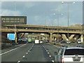
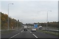
8
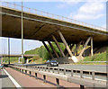
Life in the fast lane!
Parked on the M1 North admiring the bridge, a pity it's made of concrete.
Image: © Steve Fareham
Taken: 10 Sep 2007
0.17 miles
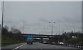
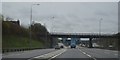
9
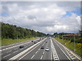
M1 near Sandiacre
The M1, looking north from Derby Road, as it passes Sandiacre (right).
Image: © Richard Vince
Taken: 7 Jul 2012
0.19 miles
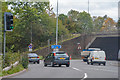
10
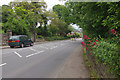
Derby Road, Sandiacre
Looking down the hill towards the centre of Sandiacre. This is now the B5010 but was once the A52, the principal route between Nottingham and Derby. For very many years Sandiacre has been by-passed by the modern A52 to the south.
Image: © Stephen McKay
Taken: 26 May 2014
0.20 miles