IMAGES TAKEN NEAR TO
Barker Avenue East, NOTTINGHAM, NG10 5GH
Introduction
This page details the photographs taken nearby to Barker Avenue East, NG10 5GH by members of the Geograph project.
The Geograph project started in 2005 with the aim of publishing, organising and preserving representative images for every square kilometre of Great Britain, Ireland and the Isle of Man.

There are currently over 7.5m images from over14,400 individuals and you can help contribute to the project by visiting https://www.geograph.org.uk
Image Map
Images are licensed for reuse under creativecommons.org/licenses/by-sa/2.0
Notes
- Clicking on the map will re-center to the selected point.
- The higher the marker number, the further away the image location is from the centre of the postcode.
Image Listing (3 Images Found)
Images are licensed for reuse under creativecommons.org/licenses/by-sa/2.0
Image
Details
Distance
1
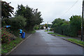
Stanton Road in Sandiacre
A road of detached and semi-detached houses on the edge of Sandiacre.
Image: © Malcolm Neal
Taken: 15 Oct 2019
0.13 miles
2
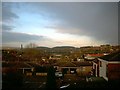
Sandiacre in the rain
View over sandiacre from devon Close
Image: © Tom Hooper
Taken: 13 Aug 2005
0.23 miles
3
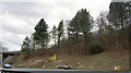
Grubbing up tree stumps
Removing trees and vegetation on the M1 North. Southbound was stationary due to a lorry shedding its load.
Image: © Steve Fareham
Taken: 5 Mar 2008
0.24 miles