IMAGES TAKEN NEAR TO
The Greenway, NOTTINGHAM, NG10 5FP
Introduction
This page details the photographs taken nearby to The Greenway, NG10 5FP by members of the Geograph project.
The Geograph project started in 2005 with the aim of publishing, organising and preserving representative images for every square kilometre of Great Britain, Ireland and the Isle of Man.

There are currently over 7.5m images from over14,400 individuals and you can help contribute to the project by visiting https://www.geograph.org.uk
Image Map
Images are licensed for reuse under creativecommons.org/licenses/by-sa/2.0
Notes
- Clicking on the map will re-center to the selected point.
- The higher the marker number, the further away the image location is from the centre of the postcode.
Image Listing (55 Images Found)
Images are licensed for reuse under creativecommons.org/licenses/by-sa/2.0
Image
Details
Distance
1
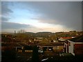
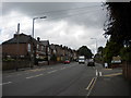
Sandiacre in the rain
View over sandiacre from devon Close
Image: © Tom Hooper
Taken: 13 Aug 2005
0.12 miles
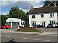
2
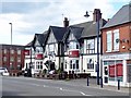
The White Lion
There has been a White Lion here since at least the 19th century but this one replaced an earlier building some time in the 1920s or 30s.
Image: © Ian Calderwood
Taken: 2 Apr 2017
0.17 miles
3
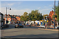
Town Centre, Sandiacre from the bridge over the canal
In 1268, King Henry III granted permission for a weekly market to take place here. There was also an annual fair that lasted for 8 days. The white building left of centre by the postbox is the small post office. The Co-op supermarket is behind the trees. The Red Lion pub is on the right. The road ahead is now the B5010 (formerly A52).
Image: © David Pinney
Taken: 21 Oct 2007
0.18 miles
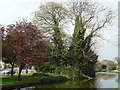
4
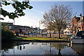
Town Centre, Sandiacre from Erewash Canal
The inn on the right is The Red Lion.
On the left, out of view, is the road bridge with traffic lights. The road ahead was once the A52 before the bypass was built. This is now the B5010.
The grassy area is part of Padmore Moorings where, in 1813, there were lime kilns to produce lime for farms.
Image: © David Pinney
Taken: 21 Oct 2007
0.18 miles
5
Derby Road, Sandiacre
Looking up Derby Road near its junction with Smedley's Avenue (right). This part of Derby Road was a surprisingly stiff climb.
Image: © Richard Vince
Taken: 7 Jul 2012
0.19 miles
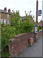
6
Sandiacre - Town Street Garage
Garage and adjacent 61 Town Street
Image: © David Barnes
Taken: 28 Aug 2006
0.19 miles
8
Old milepost, Derby Road, Sandiacre
See http://www.geograph.org.uk/photo/3948040 for close up. The top of the milepost is well polished from use as a footrest by waiting bus passengers.
Image: © Alan Murray-Rust
Taken: 20 Apr 2014
0.20 miles
9
Old milepost, Derby Road, Sandiacre
Early 19th century cast-iron turnpike milepost, inscribed NOTTM 7 MILES and DERBY 9 MILES. Listed Grade II. See http://www.geograph.org.uk/photo/3948046 for location.
Image: © Alan Murray-Rust
Taken: 20 Apr 2014
0.20 miles
10
Old Milepost by the B5010 by Derby Road, Sandiacre
Cast iron post by the B5010, in parish of SANDIACRE (EREWASH District), Derby Road; near No. 103, West of village centre, in tarmac path in front of brick wall, on North side of road. Derby iron bobbin, erected by the Nottingham Road (from Derby to Risley) turnpike trust in the 19th century.
Inscription reads:-
: NOTT.M / 7 / MILES : : DERBY / 9 / MILES : : HARRIS(ON.DERBY) :
Grade II Listed. List Entry Number:1087918
https://historicengland.org.uk/listing/the-list/list-entry/1087918
Milestone Society National ID: DE_DENT09.
Image: © J Higgins
Taken: 1 Mar 2002
0.20 miles