IMAGES TAKEN NEAR TO
Westminster Avenue, NOTTINGHAM, NG10 5AT
Introduction
This page details the photographs taken nearby to Westminster Avenue, NG10 5AT by members of the Geograph project.
The Geograph project started in 2005 with the aim of publishing, organising and preserving representative images for every square kilometre of Great Britain, Ireland and the Isle of Man.

There are currently over 7.5m images from over14,400 individuals and you can help contribute to the project by visiting https://www.geograph.org.uk
Image Map
Images are licensed for reuse under creativecommons.org/licenses/by-sa/2.0
Notes
- Clicking on the map will re-center to the selected point.
- The higher the marker number, the further away the image location is from the centre of the postcode.
Image Listing (145 Images Found)
Images are licensed for reuse under creativecommons.org/licenses/by-sa/2.0
Image
Details
Distance
1
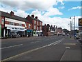
Station Road in Sandiacre
The B5010 Road pictured here at the junction with Mark Street.
Image: © Jonathan Clitheroe
Taken: 15 Aug 2013
0.05 miles
2
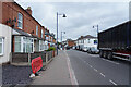
Station Road
There is a queue of traffic for the lights on the junction which is in the direction the vehicles are facing.
Image: © Malcolm Neal
Taken: 24 Jun 2021
0.06 miles
3
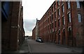
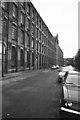
Bridge Street Sandiacre looking south
On the right is the former Springfield Mill, now converted to loft apartments
Image: © Alan Murray-Rust
Taken: 11 Nov 2007
0.07 miles
4
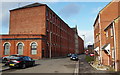
Bridge Street, Sandiacre, Derbys.
The Grade II-listed former Springfield Mill on Bridge Street. The mill was built in 1888 as a tenanted lace factory, for Terah Hooley a wealthy local industrialist, by the architect John Sheldon of Long Eaton and it now houses 105 residential units. Canal Street is on the left, opposite some newer housing units on the right of the picture.
Image: © David Hallam-Jones
Taken: 14 Feb 2013
0.08 miles
5
Springfield Mill, Sandiacre
A tenement lace factory. Was home to a Merryweather stationary steam fire pump. Now at Papplewick Pumping Station.
Image: © Chris Allen
Taken: 8 Sep 1984
0.08 miles
6
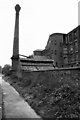
Springfield Mill, Sandiacre
Tenement lace factory beside the Erewash Canal (just to left of towpath).
Image: © Chris Allen
Taken: 8 Sep 1984
0.08 miles
8
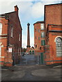
Canal Street, Sandiacre, Derbys.
The entrance to the yard of the Grade II-listed former Springfield Mill on Canal Street. The mill was built in 1888 as a tenanted lace factory, for Terah Hooley a wealthy local industrialist, by the architect John Sheldon of Long Eaton and it now houses 105 residential units.
Image: © David Hallam-Jones
Taken: 14 Feb 2013
0.08 miles
9
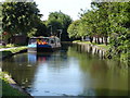
Boats on the Erewash Canal
There are usually 2 or 3 boats moored on this short stretch of the canal in the summer months, presumably so the owners can use the facilities in Sandiacre High Street. The boat in this picture is much wider than the narrow boats usually seen on the canal here, and I suspect it is too big to pass Sandiacre lock further up the canal.
Image: © Oxymoron
Taken: 21 Jul 2008
0.08 miles
10
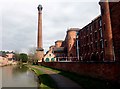
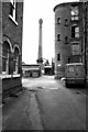
Springfield Mill and the Erewash Canal
The mill is a former Victorian lace mill. Both the mill and its chimney are grade II listed.
Image: © Graham Hogg
Taken: 20 Mar 2018
0.08 miles