IMAGES TAKEN NEAR TO
Cavendish Road, NOTTINGHAM, NG10 4HY
Introduction
This page details the photographs taken nearby to Cavendish Road, NG10 4HY by members of the Geograph project.
The Geograph project started in 2005 with the aim of publishing, organising and preserving representative images for every square kilometre of Great Britain, Ireland and the Isle of Man.

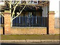
There are currently over 7.5m images from over14,400 individuals and you can help contribute to the project by visiting https://www.geograph.org.uk
Image Map
Images are licensed for reuse under creativecommons.org/licenses/by-sa/2.0
Notes
- Clicking on the map will re-center to the selected point.
- The higher the marker number, the further away the image location is from the centre of the postcode.
Image Listing (114 Images Found)
Images are licensed for reuse under creativecommons.org/licenses/by-sa/2.0
Image
Details
Distance
1
Gloucester House
On Wellington Street. This quite prestigious office building has been empty for at least two years.
Image: © David Lally
Taken: 2 Apr 2010
0.04 miles
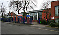
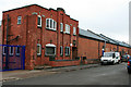
2
Offices of the JDP Group
On Wellington Street.
Image: © David Lally
Taken: 25 Mar 2010
0.06 miles
3
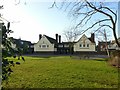
Highfields Schools ? Junior School
The three main gables facing Ingham Road. The surrounding wall and railings are listed separately from the buildings.
Image: © Alan Murray-Rust
Taken: 1 Jan 2018
0.07 miles
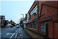
4
Mill on Wellington Street
Having moved out of the Cavendish / Britannia Mills on Bennett Street in 2009. Wade Springs remains in operation from here.
Image: © David Lally
Taken: 25 Mar 2010
0.08 miles
5
Highfields Schools
Detail of railings surrounding the schools. The panels are all identical.
Image: © Alan Murray-Rust
Taken: 1 Jan 2018
0.08 miles
6
Highfields Schools ? Junior School
The former Junior School seen across its playground.
Image: © Alan Murray-Rust
Taken: 1 Jan 2018
0.08 miles
7
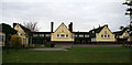
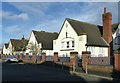
Highfield School revamped
Derbyshire County Council had planned to close this primary school in August 2008. The campaign to save it has apparently been successful as with some refurbishment (or at least a lick of paint on the outside) it is still open.
Being cynical I expect that it was not the campaign which was the reason for its survival, but that someone (probably from Erewash Borough Council) pointed out that the buildings have been Grade II listed. As the design looks to be very difficult to convert into other use, closure would simply have meant that the County was left with a site of dilapidated buildings which no one wanted and could not be demolished to sell the land.
Image: © David Lally
Taken: 2 Apr 2010
0.08 miles
8
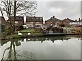
Swans on the bank of the Erewash Canal
Just north of Long Eaton.
Image: © Andrew Abbott
Taken: 28 Dec 2019
0.09 miles
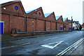
9
Highfield Mills
On Canal Street, between College Street and Wellington Street.
Image: © David Lally
Taken: 2 Apr 2010
0.09 miles
10
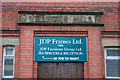
Title stone Wellington Mills, 1907
This doorway is on Canal Street the offices referred to in the JDP sign are around the corner on Wellington Street, http://www.geograph.org.uk/photo/1777542 .
Image: © David Lally
Taken: 25 Mar 2010
0.09 miles