IMAGES TAKEN NEAR TO
Bennett Street, NOTTINGHAM, NG10 4HH
Introduction
This page details the photographs taken nearby to Bennett Street, NG10 4HH by members of the Geograph project.
The Geograph project started in 2005 with the aim of publishing, organising and preserving representative images for every square kilometre of Great Britain, Ireland and the Isle of Man.

There are currently over 7.5m images from over14,400 individuals and you can help contribute to the project by visiting https://www.geograph.org.uk
Image Map
Images are licensed for reuse under creativecommons.org/licenses/by-sa/2.0
Notes
- Clicking on the map will re-center to the selected point.
- The higher the marker number, the further away the image location is from the centre of the postcode.
Image Listing (125 Images Found)
Images are licensed for reuse under creativecommons.org/licenses/by-sa/2.0
Image
Details
Distance
1
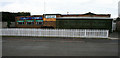
Curzon Club
On Bennett Street, rather than Curzon Street. Still displaying a Mansfield Beers sign, the Mansfield brewery closed in 2003.
Image: © David Lally
Taken: 2 Apr 2010
0.01 miles
2
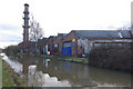
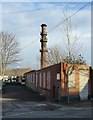
Erewash Canal, Long Eaton
The Erewash Canal finds a largely industrial route through Long Eaton; in this view, the factory on the right is the premises of John Whiteman Ltd, an engineering and powder coating firm. Note the chimney being used as a telecommunications mast.
Image: © Stephen McKay
Taken: 1 Jan 2010
0.02 miles
3
Dumb barge and pusher, Erewash Canal
Image: © Jonathan Thacker
Taken: 26 Jan 2022
0.02 miles
4
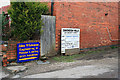
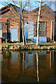
Company Signs
Advertising the firms which now (or recently) occupy the rear of this mill complex.
Image: © David Lally
Taken: 30 Jan 2009
0.03 miles
5
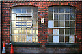
Mill Windows
The light in the left hand one is there because the building behind has been demolished.
Image: © David Lally
Taken: 13 Mar 2010
0.03 miles
6

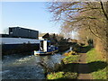
Swan on the Erewash Canal
About halfway between Derby Road and Dockholme Lock.
Image: © David Lally
Taken: 13 Mar 2010
0.03 miles
7
The remains of Portland Mills, Bennett Street
Only the chimney remains. The rest of the site is subject of a planning application for around 100 dwellings.
There is a bench mark http://www.geograph.org.uk/photo/5643487 on the corner.
Image: © Alan Murray-Rust
Taken: 1 Jan 2018
0.03 miles
8
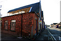
Semi demolished mill
On Bennett Street.
Image: © David Lally
Taken: 13 Mar 2010
0.03 miles
9
Former lunch spot
Small table and chairs set outside canal-side mill. No one with have their break here again as most of the building behind is now demolished.
Image: © David Lally
Taken: 13 Mar 2010
0.04 miles
10
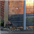
Bench mark, Bennett Street, Long Eaton
See http://www.geograph.org.uk/photo/5643484 for location.
Image: © Alan Murray-Rust
Taken: 1 Jan 2018
0.04 miles