IMAGES TAKEN NEAR TO
Quantock Road, NOTTINGHAM, NG10 4GZ
Introduction
This page details the photographs taken nearby to Quantock Road, NG10 4GZ by members of the Geograph project.
The Geograph project started in 2005 with the aim of publishing, organising and preserving representative images for every square kilometre of Great Britain, Ireland and the Isle of Man.

There are currently over 7.5m images from over14,400 individuals and you can help contribute to the project by visiting https://www.geograph.org.uk
Image Map
Images are licensed for reuse under creativecommons.org/licenses/by-sa/2.0
Notes
- Clicking on the map will re-center to the selected point.
- The higher the marker number, the further away the image location is from the centre of the postcode.
Image Listing (22 Images Found)
Images are licensed for reuse under creativecommons.org/licenses/by-sa/2.0
Image
Details
Distance
1
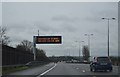
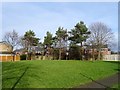
Beyond The Sound Barrier
A fence on the eastern side of the M1 near Long Eaton is supposed to act as a sound barrier for residents of the properties living on the housing estate on the other side. I don't think it is 100% effective if the noise of the passing traffic was anything to go by when I took this photo. The proximity of the motorway can be judged by the gantry carrying the overhead signs just beyond the fence.
Image: © Garth Newton
Taken: 8 Feb 2006
0.01 miles
4

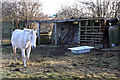
Breaston : Grassy Field
An equestrian event takes place in the field.
Image: © Lewis Clarke
Taken: 20 Sep 2020
0.12 miles
5
Green space off Pennine Close
A small sliver of green space in amongst the houses.
Image: © Ian Calderwood
Taken: 12 Feb 2018
0.16 miles
6

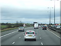
Erewash : M1 Motorway
The M1 Motorway between Junction 24A and Junction 25 (Sandiacre).
Image: © Lewis Clarke
Taken: 30 Sep 2018
0.16 miles
7
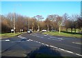
Petersham Road in Wilsthorpe
The B6002 pictured here at its junction with Longmoor Lane on the left.
Image: © Jonathan Clitheroe
Taken: 29 Dec 2013
0.19 miles
8
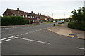
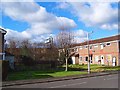
Briar Gate, Long Eaton 8
Image: © David Lally
Taken: 14 Jul 2008
0.20 miles
9
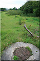
Along The Line of The Canal
The patch of nettles ahead I think indicates the line of the Derby and Sandiacre Canal. Perhaps the manhole cover in the foreground has something to do with it too?
There is a society http://www.derbycanal.org.uk/ dedicated to the reopening of this waterway. This would seem to me to be a herculean task, with many obstacles to remove, not least the embankment of the M1 behind the photographer!
Image: © David Lally
Taken: 14 Jul 2008
0.20 miles