IMAGES TAKEN NEAR TO
Malvern Gardens, NOTTINGHAM, NG10 4FW
Introduction
This page details the photographs taken nearby to Malvern Gardens, NG10 4FW by members of the Geograph project.
The Geograph project started in 2005 with the aim of publishing, organising and preserving representative images for every square kilometre of Great Britain, Ireland and the Isle of Man.

There are currently over 7.5m images from over14,400 individuals and you can help contribute to the project by visiting https://www.geograph.org.uk
Image Map
Images are licensed for reuse under creativecommons.org/licenses/by-sa/2.0
Notes
- Clicking on the map will re-center to the selected point.
- The higher the marker number, the further away the image location is from the centre of the postcode.
Image Listing (27 Images Found)
Images are licensed for reuse under creativecommons.org/licenses/by-sa/2.0
Image
Details
Distance
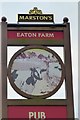
2
Eaton Farm
A pub and restaurant on the A6005 at the western edge of Long Eaton. The building on the left appears to be the old farmhouse. This is not part of the pub - it houses the kitchens etc.
It has recently undergone refurbishment.
Image: © David Lally
Taken: 8 Feb 2009
0.10 miles
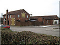
4
Eaton Farm
Typical Marston's eating pub on the outskirts of town.
Image: © David Lally
Taken: 31 Dec 2016
0.10 miles
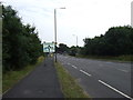
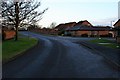
5
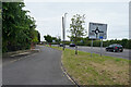
Derby Road
The main road is Derby Road the A6005 and parallel to it is a loop road with houses to the south. I cannot find a name for this loop road so it may also be Derby Road.
Image: © Malcolm Neal
Taken: 17 Jun 2021
0.10 miles
6
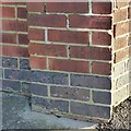
Bench mark, Parkside Avenue substation
As difficult to see in the photo as in reality – near top right on the red brick. See http://www.geograph.org.uk/photo/5647496 for location.
Image: © Alan Murray-Rust
Taken: 7 Jan 2018
0.11 miles
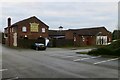
7
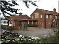
Eaton Farm
A pub and restaurant on the A6005 at the western edge of Long Eaton. The two storey building on the right appears to be the old farmhouse. This is not part of the pub - that is all in the single storey to the left.
It has recently undergone refurbishment.
Image: © David Lally
Taken: 8 Feb 2009
0.11 miles
8
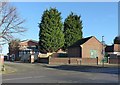
Electricity substation, Parkside Avenue
There is a bench mark http://www.geograph.org.uk/photo/5647498 on the pier at the angle of the perimeter wall.
Image: © Alan Murray-Rust
Taken: 7 Jan 2018
0.12 miles
9
Eaton Grange Drive
The entrance into an estate of 1990's detached properties on the very western edge of Long Eaton.
Image: © David Lally
Taken: 10 Feb 2010
0.13 miles
10
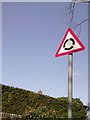
UK Roundabout Ahead Sign
UK Roundabout Ahead Sign in Long Eaton Derbyshire.
Image: © gary
Taken: 3 Mar 2015
0.14 miles