IMAGES TAKEN NEAR TO
Cheviot Road, NOTTINGHAM, NG10 4FU
Introduction
This page details the photographs taken nearby to Cheviot Road, NG10 4FU by members of the Geograph project.
The Geograph project started in 2005 with the aim of publishing, organising and preserving representative images for every square kilometre of Great Britain, Ireland and the Isle of Man.

There are currently over 7.5m images from over14,400 individuals and you can help contribute to the project by visiting https://www.geograph.org.uk
Image Map
Images are licensed for reuse under creativecommons.org/licenses/by-sa/2.0
Notes
- Clicking on the map will re-center to the selected point.
- The higher the marker number, the further away the image location is from the centre of the postcode.
Image Listing (15 Images Found)
Images are licensed for reuse under creativecommons.org/licenses/by-sa/2.0
Image
Details
Distance
1
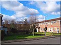
Green space off Pennine Close
A small sliver of green space in amongst the houses.
Image: © Ian Calderwood
Taken: 12 Feb 2018
0.05 miles
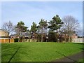
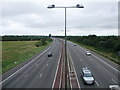
2
Erewash : M1 Motorway
The M1 Motorway between Junction 24A and Junction 25 (Sandiacre).
Image: © Lewis Clarke
Taken: 30 Sep 2018
0.09 miles
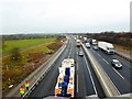
4
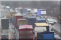
Recovery in progress
M1 northbound south of junction 25.
A close view of the front of this queue Image
Image: © David Lally
Taken: 21 Dec 2017
0.12 miles
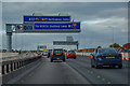
5
Beyond The Sound Barrier
A fence on the eastern side of the M1 near Long Eaton is supposed to act as a sound barrier for residents of the properties living on the housing estate on the other side. I don't think it is 100% effective if the noise of the passing traffic was anything to go by when I took this photo. The proximity of the motorway can be judged by the gantry carrying the overhead signs just beyond the fence.
Image: © Garth Newton
Taken: 8 Feb 2006
0.14 miles
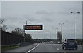
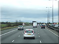
6
One lane closed northbound
An hour or two after Image
Image: © David Lally
Taken: 21 Dec 2017
0.14 miles
9
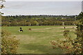
Fields of the former parish of Wilsthorpe
A view looking north of the remaining fields west of the M1 that were originally part of the former Wilsthorpe parish, which merged with Sawley parish in 1866. The fields are now part of Breaston civil parish, Derbyshire.
Image: © Clive Cartwright
Taken: 24 Sep 2022
0.17 miles
10
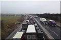
M1 Closed northbound
For a long focal length photo of the front of the queue see Image
Image: © David Lally
Taken: 21 Dec 2017
0.21 miles