IMAGES TAKEN NEAR TO
Longmoor Road, NOTTINGHAM, NG10 4FN
Introduction
This page details the photographs taken nearby to Longmoor Road, NG10 4FN by members of the Geograph project.
The Geograph project started in 2005 with the aim of publishing, organising and preserving representative images for every square kilometre of Great Britain, Ireland and the Isle of Man.

There are currently over 7.5m images from over14,400 individuals and you can help contribute to the project by visiting https://www.geograph.org.uk
Image Map
Images are licensed for reuse under creativecommons.org/licenses/by-sa/2.0
Notes
- Clicking on the map will re-center to the selected point.
- The higher the marker number, the further away the image location is from the centre of the postcode.
Image Listing (22 Images Found)
Images are licensed for reuse under creativecommons.org/licenses/by-sa/2.0
Image
Details
Distance
1
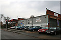
Petrol Station and garage
On the corner of Curzon Street and Longmoor Road.
Image: © David Lally
Taken: 25 Mar 2010
0.02 miles
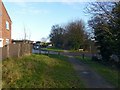
2
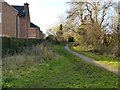
Derby Canal Path in Long Eaton
The canal has been completely filled in, although some current OS maps still show some water along here. The houses on the left front onto Longmoor Road.
Image: © Alan Murray-Rust
Taken: 7 Jan 2018
0.03 miles
3
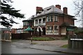
The Moorlands Club
On the corner of Moorlands Close and Curzon Street.
The building still sports a sign from Mansfield Brewery, which has not been in existence for some time now.
Image: © David Lally
Taken: 24 Mar 2010
0.07 miles
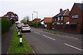
4
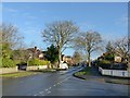
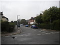
Suburban Long Eaton
Longmoor Road at Grasmere Road.
Image: © Alan Murray-Rust
Taken: 7 Jan 2018
0.07 miles
5
Derby Canal Path in Long Eaton
Crossing Springfield Road. The canal has been completely filled in.
Image: © Alan Murray-Rust
Taken: 7 Jan 2018
0.12 miles
6
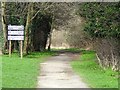
Derby Canal Path
On the line of the former Derby & Sandiacre Canal.
Image: © Ian Calderwood
Taken: 4 Mar 2017
0.13 miles
7
Park Drive, Long Eaton
Seen from the junction with Bostocks Lane.
Image: © Stephen McKay
Taken: 1 May 2016
0.14 miles
8
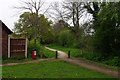
Derby Canal Walk
The route of the former Derby Canal runs past the back gardens of houses on the outskirts of Long Eaton. Plans exist to restore the old canal to a navigable waterway.
Image: © Stephen McKay
Taken: 1 May 2016
0.14 miles
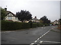
9
Ravensdale Avenue, Long Eaton
The western half of Ravensdale Avenue, seen from Breedon Street.
Image: © Richard Vince
Taken: 25 Sep 2013
0.15 miles
10
North end of Breedon Street, Long Eaton
Home to some impressively manicured hedgerows. Seen from Ravensdale Avenue.
Image: © Richard Vince
Taken: 25 Sep 2013
0.16 miles