IMAGES TAKEN NEAR TO
Breedon Street, NOTTINGHAM, NG10 4EW
Introduction
This page details the photographs taken nearby to Breedon Street, NG10 4EW by members of the Geograph project.
The Geograph project started in 2005 with the aim of publishing, organising and preserving representative images for every square kilometre of Great Britain, Ireland and the Isle of Man.

There are currently over 7.5m images from over14,400 individuals and you can help contribute to the project by visiting https://www.geograph.org.uk
Image Map
Images are licensed for reuse under creativecommons.org/licenses/by-sa/2.0
Notes
- Clicking on the map will re-center to the selected point.
- The higher the marker number, the further away the image location is from the centre of the postcode.
Image Listing (46 Images Found)
Images are licensed for reuse under creativecommons.org/licenses/by-sa/2.0
Image
Details
Distance
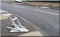
1
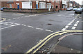
All Give Way
Most of the road junctions in this part of Long Eaton have Give Way markings and signs on all four roads.
This one is on Breedon Street, with Canal Street crossing left to right.
The system works very well as vehicles on both roads have to slow for the junction.
If an accident did occur it's quite easy to tell which should have given way - that's the one with damage to the front, if it was hit in the side then it must have entered the junction first and therefore have the right-of-way.
Image: © David Lally
Taken: 30 Dec 2007
0.11 miles
2
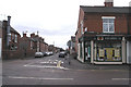
College Street Post Office
This escaped the recent closure announcements - far enough away from the main Long Eaton PO to survive.
College Street runs across the frame, the road ahead is Canal Street
Image: © David Lally
Taken: 30 Dec 2007
0.11 miles
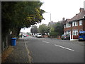
3
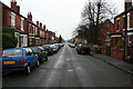
Curzon Street
As straight as they come. A mixture of detached and semi-detached villas from the early Edwardian era.
Image: © David Lally
Taken: 25 Mar 2010
0.13 miles

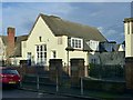
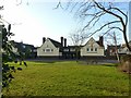
5
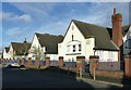
Highfields Schools ? Junior School
The three main gables facing Ingham Road. The surrounding wall and railings are listed separately from the buildings.
Image: © Alan Murray-Rust
Taken: 1 Jan 2018
0.15 miles
6
Fallen Sign
I resisted the temptation to lift it up to see what it should have been warning of, let it remain a mystery.
Image: © David Lally
Taken: 30 Dec 2007
0.15 miles
7
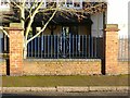
Highfields Schools
Detail of railings surrounding the schools. The panels are all identical.
Image: © Alan Murray-Rust
Taken: 1 Jan 2018
0.15 miles
8
College Street, Long Eaton (2)
Looking north from near the junction with Spinney Road.
Image: © Richard Vince
Taken: 25 Sep 2013
0.15 miles
9
Highfields Schools ? School Hall on Ingham Road side
Image: © Alan Murray-Rust
Taken: 1 Jan 2018
0.16 miles
10
Highfields Schools ? Junior School
The former Junior School seen across its playground.
Image: © Alan Murray-Rust
Taken: 1 Jan 2018
0.16 miles