IMAGES TAKEN NEAR TO
Bramble Close, NOTTINGHAM, NG10 4DX
Introduction
This page details the photographs taken nearby to Bramble Close, NG10 4DX by members of the Geograph project.
The Geograph project started in 2005 with the aim of publishing, organising and preserving representative images for every square kilometre of Great Britain, Ireland and the Isle of Man.

There are currently over 7.5m images from over14,400 individuals and you can help contribute to the project by visiting https://www.geograph.org.uk
Image Map
Images are licensed for reuse under creativecommons.org/licenses/by-sa/2.0
Notes
- Clicking on the map will re-center to the selected point.
- The higher the marker number, the further away the image location is from the centre of the postcode.
Image Listing (24 Images Found)
Images are licensed for reuse under creativecommons.org/licenses/by-sa/2.0
Image
Details
Distance
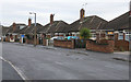
1
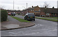
Briar Gate, Long Eaton 7
Continued from Image
After meeting with Bracken Road, Briar Gate continues to its junction with Longmoor Road with exclusively municipal housing.
Continues: Image
Image: © David Lally
Taken: 30 Dec 2007
0.06 miles
2
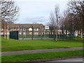
Petersham Multi Use Games Area
Billed as "multi use' but seems to be set up mainly for basketball.
Image: © Ian Calderwood
Taken: 12 Feb 2018
0.10 miles
3
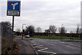
Briar Gate, Long Eaton 6
Continued from Image
At its junction with Grasmere Road Briar Gate becomes subject to traffic restrictions and heads towards the Petersham (ex)council estate.
Continues: Image
Image: © David Lally
Taken: 30 Dec 2007
0.10 miles
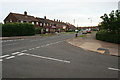
4
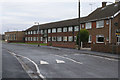
Briar Gate, Long Eaton 5
Continued from Image
The last of the 1960's private semis gives way to municipal flats. The far building is a community hall.
Continues: Image
Image: © David Lally
Taken: 30 Dec 2007
0.13 miles
5
Briar Gate, Long Eaton 4
Continued from Image
A bit further north and we have smaller 3 bed post WWII semis and this row of bungalows.
Continued: Image
Image: © David Lally
Taken: 30 Dec 2007
0.16 miles
6
Briar Gate, Long Eaton 8
Image: © David Lally
Taken: 14 Jul 2008
0.16 miles
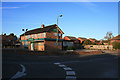
7
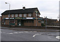
The Petersham - Long Eaton
Typical of "Estate Pubs" throughout the nation. True to form the (thankfully) locked back yard contained a German Shepherd dog which barked and strained at the gate as I passed.
Demolished in September 2010: Image
Image: © David Lally
Taken: 30 Dec 2007
0.18 miles
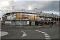
8
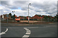
"The Petersham" now gone
A passer-by told me that the demolition started in week commencing 13th September 2010. This is how it looked: Image
Update May 2011: The site did not stay empty for long Image
Image: © David Lally
Taken: 25 Sep 2010
0.18 miles
9
The Petersham, Long Eaton
Image: © David Lally
Taken: 8 Apr 2009
0.18 miles
10
New buildings on the site of "The Petersham"
The pub was demolished about six months ago: Image
Image: © David Lally
Taken: 8 May 2011
0.18 miles