IMAGES TAKEN NEAR TO
Pasture Lane, NOTTINGHAM, NG10 2FZ
Introduction
This page details the photographs taken nearby to Pasture Lane, NG10 2FZ by members of the Geograph project.
The Geograph project started in 2005 with the aim of publishing, organising and preserving representative images for every square kilometre of Great Britain, Ireland and the Isle of Man.

There are currently over 7.5m images from over14,400 individuals and you can help contribute to the project by visiting https://www.geograph.org.uk
Image Map
Images are licensed for reuse under creativecommons.org/licenses/by-sa/2.0
Notes
- Clicking on the map will re-center to the selected point.
- The higher the marker number, the further away the image location is from the centre of the postcode.
Image Listing (84 Images Found)
Images are licensed for reuse under creativecommons.org/licenses/by-sa/2.0
Image
Details
Distance
1
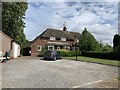
Cottages at Home Farm
On Pasture Lane, Long Eaton
Image: © Andrew Abbott
Taken: 24 May 2020
0.01 miles
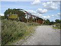
6
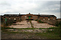
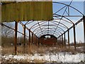
Abandoned building
On Pasture Lane, Long Eaton. It's previous function is obscure, but it must have been in use relatively recently as it has a Heath and Safety "inspired" Fire Assembly Point sign.
Image: © David Lally
Taken: 8 Aug 2010
0.04 miles
7
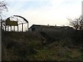
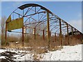
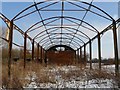
Abandoned farm on Pasture Lane Long Eaton
Image: © Andy Jamieson
Taken: 24 Dec 2008
0.05 miles