IMAGES TAKEN NEAR TO
Trent Cottages, NOTTINGHAM, NG10 2FW
Introduction
This page details the photographs taken nearby to Trent Cottages, NG10 2FW by members of the Geograph project.
The Geograph project started in 2005 with the aim of publishing, organising and preserving representative images for every square kilometre of Great Britain, Ireland and the Isle of Man.

There are currently over 7.5m images from over14,400 individuals and you can help contribute to the project by visiting https://www.geograph.org.uk
Image Map
Images are licensed for reuse under creativecommons.org/licenses/by-sa/2.0
Notes
- Clicking on the map will re-center to the selected point.
- The higher the marker number, the further away the image location is from the centre of the postcode.
Image Listing (36 Images Found)
Images are licensed for reuse under creativecommons.org/licenses/by-sa/2.0
Image
Details
Distance
1
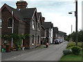
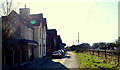
Trent Cottages
Built by the Midland Railway for staff working at the important Trent Junction. This was a major railway crossroads at the crossing of the Nottingham-Derby and London-Sheffield (direct) lines. The latter in particular carried very heavy volumes of coal from Yorkshire, Nottinghamshire and Derbyshire towards London.
Image: © Alan Murray-Rust
Taken: 21 Jun 2009
0.00 miles
2
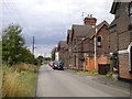
Trent Cottages, Long Eaton
Unmistakably Midland Railway railwaymen's cottages near Trent Junction.
Image: © Richard Vince
Taken: 17 Aug 2015
0.01 miles
5
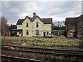
Trent Cottages, Long Eaton, Derbys.
Several of the former railway company houses known as Trent Cottages in a truncated cul-de-sac that is also called Trent Cottages, with a view of some of the parallel railway tracks. One of the residents was keen to point out how distressed the inhabitants are about the fact that the route of the proposed HS2 railway service from Birmingham to the north of England via Toton sidings is likely to mean that new railway lines will be constructed from left to right across this plot.
Image: © David Hallam-Jones
Taken: 17 Feb 2013
0.04 miles
6
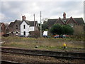
Trent power box, Long Eaton
The north end of Trent power signal box, seen from Trent Cottages. Trent power box closed in July 2013 at the beginning of the Nottingham resignalling project.
Image: © Richard Vince
Taken: 17 Aug 2015
0.04 miles
7
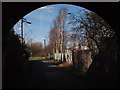
Trent Cottages, Long Eaton, Derbys.
This truncated cul-de-sac is called "Trent Cottages" on account of the row of former railway company houses that exist ahead on the left. This shot was taken from beneath a bridge that regularly carries engines and rolling stock overhead, whilst the railway lines beyond the distant fencing are used for other trains and services. On the right, behind the security fencing, is a railway maintenance depot.
Image: © David Hallam-Jones
Taken: 17 Feb 2013
0.05 miles
8
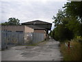
Trent Cottages
The access road to the cottages of the same name, the signal box and a Network Rail maintenance depot. Various pieces of track maintenance equipment were being loaded onto a low loader on roads which really are not suitable for the purpose. The bridge carries the high level freight lines from the Erewash Valley line onto the main London line.
Image: © Alan Murray-Rust
Taken: 21 Jun 2009
0.05 miles
9
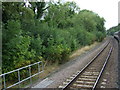
Railway heading north near Long Eaton
Towards Alfreton, Chesterfield and Sheffield.
Image: © JThomas
Taken: 17 Aug 2013
0.05 miles
10
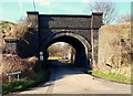
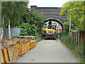
Trent Lane, Long Eaton, Derbys.
The entrance to a truncated cul-de-sac known as Trent Cottages, as are the cottages in this road taking their name. This side road is off Trent Lane, a road that links Meadow Lane - to the right - and the Cranfleet Canal in the opposite direction. The bridge is used by engines and rolling stock and beyond the security fence on the other side of the bridge are further lines that carry high-speed main-line trains.
Image: © David Hallam-Jones
Taken: 17 Feb 2013
0.05 miles