IMAGES TAKEN NEAR TO
Newbery Avenue, NOTTINGHAM, NG10 2FT
Introduction
This page details the photographs taken nearby to Newbery Avenue, NG10 2FT by members of the Geograph project.
The Geograph project started in 2005 with the aim of publishing, organising and preserving representative images for every square kilometre of Great Britain, Ireland and the Isle of Man.

There are currently over 7.5m images from over14,400 individuals and you can help contribute to the project by visiting https://www.geograph.org.uk
Image Map
Images are licensed for reuse under creativecommons.org/licenses/by-sa/2.0
Notes
- Clicking on the map will re-center to the selected point.
- The higher the marker number, the further away the image location is from the centre of the postcode.
Image Listing (79 Images Found)
Images are licensed for reuse under creativecommons.org/licenses/by-sa/2.0
Image
Details
Distance
2
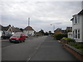
Owen Avenue, Long Eaton (1)
Looking south from Junction Road.
Image: © Richard Vince
Taken: 17 Aug 2015
0.04 miles
3
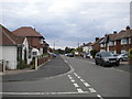
Owen Avenue, Long Eaton (2)
Looking north from Junction Road.
Image: © Richard Vince
Taken: 17 Aug 2015
0.04 miles
4
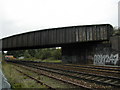
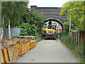
Rail Bridge over a railway
Rail bridge over the Nottingham - London mainline at SK 499 327. In this area there are several large rail junctions. Where the lines for Derby and Nottingham split.
Image: © Peter Shone
Taken: 18 Sep 2005
0.08 miles
5
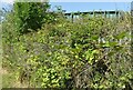
Rail Bridge over a railway
Recreating this 'First' for the square https://www.geograph.org.uk/photo/55107 , from about as close to the original camera location as the subsequent increase in vegetation will allow. The bridge itself has been repainted in the meantime.
Image: © Alan Murray-Rust
Taken: 8 Jul 2022
0.08 miles
6
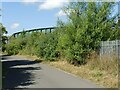
Rail Bridge over a railway
Recreating this 'First' for the square https://www.geograph.org.uk/photo/55107 , although taken a bit further away to give some sense of the bridge.
This alternative view https://www.geograph.org.uk/photo/7222060 is probably as close to the actual camera location as it is currently possible to get!
Image: © Alan Murray-Rust
Taken: 8 Jul 2022
0.08 miles
7
Owen Avenue
Part of a small self-contained housing development to the south-east of the railway line.
Image: © Alan Murray-Rust
Taken: 21 Jun 2009
0.08 miles
8
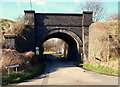
Trent Lane, Long Eaton, Derbys.
The entrance to a truncated cul-de-sac known as Trent Cottages, as are the cottages in this road taking their name. This side road is off Trent Lane, a road that links Meadow Lane - to the right - and the Cranfleet Canal in the opposite direction. The bridge is used by engines and rolling stock and beyond the security fence on the other side of the bridge are further lines that carry high-speed main-line trains.
Image: © David Hallam-Jones
Taken: 17 Feb 2013
0.10 miles
9
Trent Cottages
The access road to the cottages of the same name, the signal box and a Network Rail maintenance depot. Various pieces of track maintenance equipment were being loaded onto a low loader on roads which really are not suitable for the purpose. The bridge carries the high level freight lines from the Erewash Valley line onto the main London line.
Image: © Alan Murray-Rust
Taken: 21 Jun 2009
0.11 miles
10
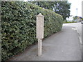
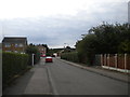
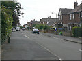
Old Barton bus stop, Newbery Avenue, Long Eaton
Few of the very distinctive short concrete bus stops installed by former Nottinghamshire independent Barton Buses survive. This one is on a road which, I believe, is no longer bus served.
Image: © Richard Vince
Taken: 17 Aug 2015
0.11 miles