IMAGES TAKEN NEAR TO
Denacre Avenue, NOTTINGHAM, NG10 2BJ
Introduction
This page details the photographs taken nearby to Denacre Avenue, NG10 2BJ by members of the Geograph project.
The Geograph project started in 2005 with the aim of publishing, organising and preserving representative images for every square kilometre of Great Britain, Ireland and the Isle of Man.

There are currently over 7.5m images from over14,400 individuals and you can help contribute to the project by visiting https://www.geograph.org.uk
Image Map
Images are licensed for reuse under creativecommons.org/licenses/by-sa/2.0
Notes
- Clicking on the map will re-center to the selected point.
- The higher the marker number, the further away the image location is from the centre of the postcode.
Image Listing (344 Images Found)
Images are licensed for reuse under creativecommons.org/licenses/by-sa/2.0
Image
Details
Distance
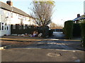
1
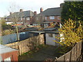
Terraced house gardens
Also known as China town when everyone has washing on the line
Image: © Andy Jamieson
Taken: 23 Nov 2008
0.02 miles
5
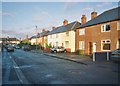
Margaret Avenue Long Eaton
Also known as "China Town"
Image: © Andy Jamieson
Taken: 24 Dec 2005
0.03 miles
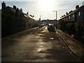
8
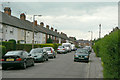
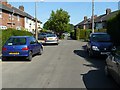
Landsdown Grove
Inter-war Council housing development to the north of Long Eaton town centre.
Image: © Alan Murray-Rust
Taken: 24 Jun 2010
0.04 miles
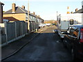
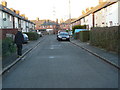
9
Doncaster Grove
Towards the end that turns right into Margaret ave. There area few houses not on the road
Image: © Andy Jamieson
Taken: 31 May 2009
0.04 miles
10
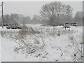
Toton Manor Park
Bridges over The Erewash
Image: © Andy Jamieson
Taken: 5 Feb 2009
0.04 miles