IMAGES TAKEN NEAR TO
New Street, NOTTINGHAM, NG10 1HE
Introduction
This page details the photographs taken nearby to New Street, NG10 1HE by members of the Geograph project.
The Geograph project started in 2005 with the aim of publishing, organising and preserving representative images for every square kilometre of Great Britain, Ireland and the Isle of Man.

There are currently over 7.5m images from over14,400 individuals and you can help contribute to the project by visiting https://www.geograph.org.uk
Image Map
Images are licensed for reuse under creativecommons.org/licenses/by-sa/2.0
Notes
- Clicking on the map will re-center to the selected point.
- The higher the marker number, the further away the image location is from the centre of the postcode.
Image Listing (333 Images Found)
Images are licensed for reuse under creativecommons.org/licenses/by-sa/2.0
Image
Details
Distance
2
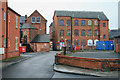
Former lace factory on Brown's Road
Dated 1857 in the left hand gable http://www.geograph.org.uk/photo/5658546 it is probably one of the oldest surviving textile factories in the town. Listed Grade II.
Image: © Alan Murray-Rust
Taken: 19 Jan 2018
0.03 miles
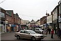
3
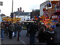
High Street, Long Eaton
Recreating this 'First' for the square https://www.geograph.org.uk/photo/18922
Image: © Alan Murray-Rust
Taken: 1 Mar 2022
0.03 miles
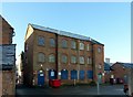
4
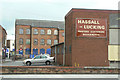
J and H Lacey Warehouse
As well as the impressive mills by the side of the Erewash Canal and Derby Road (e.g. http://www.geograph.org.uk/photo/602584). There remains, dotted around Long Eaton, smaller surviving lace related buildings.
This one was originally a warehouse and is just behind the shops on the high street, seen here from Cross Street.
List Entry Number:1204201. https://historicengland.org.uk/listing/the-list/list-entry/1204201
It was Grade II listed in 1986.
Image: © David Lally
Taken: 1 Feb 2009
0.03 miles
5
Industrial buildings in Long Eaton
Buildings from the 19th and 20th centuries. These buildings are, surprisingly, in the heart of the retail centre of Long Eaton.
Image: © Alan Murray-Rust
Taken: 24 Jun 2010
0.03 miles
6
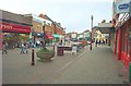
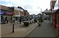
High Street, Long Eaton
Long Eaton is mentioned in the Domesday Book as Aitone.
Image: © Garth Newton
Taken: 13 Jun 2005
0.04 miles
7
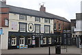
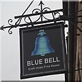
The Blue Bell, Long Eaton
37 High Street, Long Eaton. A public house, built in the eighteenth century. It is faced with smooth render beneath a slate roof. The front elevation is of three storeys. The first floor has three irregularly spaced sash windows with lugged architraves.
Image: © Andrew Abbott
Taken: 16 Jun 2019
0.04 miles
8
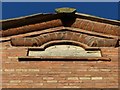
Datestone, Lace factory on Brown's Road
With the growth of the town, this is the only available view of the datestone, looking up in the narrow alley which passes the building. It was presumably more visible when the factory was built! See http://www.geograph.org.uk/photo/5658565 for location.
Image: © Alan Murray-Rust
Taken: 19 Jan 2018
0.04 miles
9
High Street, Long Eaton
Taken as a comparison to a Francis Frith Collection picture from c1950.
http://www.francisfrith.com/long-eaton/photos/high-street-c1950_l198002/
The main reference points are the Burton and Woolworth buildings at the bend in the road and the tower of the Co-op above the roofs. W H Smith now stands on the site of The Empire cinema.
Image: © David Lally
Taken: 28 Dec 2010
0.04 miles