IMAGES TAKEN NEAR TO
Mill Court, Stanley Street, NOTTINGHAM, NG10 1EL
Introduction
This page details the photographs taken nearby to Mill Court, Stanley Street, NG10 1EL by members of the Geograph project.
The Geograph project started in 2005 with the aim of publishing, organising and preserving representative images for every square kilometre of Great Britain, Ireland and the Isle of Man.

There are currently over 7.5m images from over14,400 individuals and you can help contribute to the project by visiting https://www.geograph.org.uk
Image Map
Images are licensed for reuse under creativecommons.org/licenses/by-sa/2.0
Notes
- Clicking on the map will re-center to the selected point.
- The higher the marker number, the further away the image location is from the centre of the postcode.
Image Listing (317 Images Found)
Images are licensed for reuse under creativecommons.org/licenses/by-sa/2.0
Image
Details
Distance
1
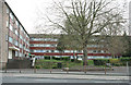
Flats on Tamworth Road
The nearest thing to a 1960's towerblock you get in Long Eaton.
Image: © David Lally
Taken: 27 Apr 2008
0.03 miles
2
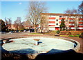
Romorantin Place, Long Eaton, Derbys.
A glance across this mid-60s Square shows traffic on Tamworth Road (the B6540) heading towards Market Place with a glimpse of the Library Gardens beyond it. The square and the housing complex that overlooks it on two sides was so named to commemorate the 1961 town-twinning partnership with Romorantin-Lanthenay in the Loire Valley, an arrangement that stemmed initially from contacts between the rugby clubs of these two towns. Unfortunately one of the two residential blocks has been empty for the last 2-3 years.
Image: © David Hallam-Jones
Taken: 17 Feb 2013
0.05 miles
3
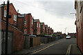
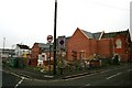
Northcote Street
One side of this street consists of the rear of the houses on Salisbury Street.
Image: © David Lally
Taken: 27 Apr 2008
0.06 miles
4
Long Eaton Silver Prize Band Social Club
Closed in January 2015 http://www.silverprizebandclub.org.uk
The band is still going strong: http://www.lespb.org.uk
Image: © David Lally
Taken: 8 May 2016
0.06 miles
5
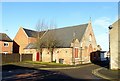
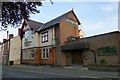
Former Methodist Sunday School, Orchard Street
Now forming part of the Chatsworth Arts Centre https://www.geograph.org.uk/photo/1916470
Image: © Alan Murray-Rust
Taken: 19 Jan 2018
0.06 miles
6
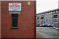
Private Car Park
This sign shows its age with the clamp removal fee quoted - a mere £10!
The car park belongs to The Long Eaton Silver Band Club on Salisbury Street
Image: © David Lally
Taken: 1 Feb 2009
0.06 miles
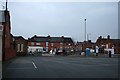
8
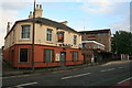
The Wheatsheaf
The blackboard announces "Sky Sports Now Showing" I don't think so.
I did not know Long Eaton during the days of the three Nottingham breweries (Home, Shipstones and Kimberley's) but at a guess I'd say this was a Shipstones house.
Image: © David Lally
Taken: 7 Sep 2008
0.07 miles
9
No more theatre plans?
The steel framework for a new theatre on this site (see http://www.geograph.org.uk/photo/1143308 ) has been removed.
Image: © David Lally
Taken: 25 Jan 2010
0.07 miles
10
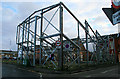
Skeleton Theatre Emerges from the Ashes
Here stood a church building which had been converted to a local theatre.
It was gutted by fire in late 2004.
A fund was created to rebuild it appropriately called The Phoenix Fund.
In 2006 it had raised enough money to start the construction, then the funds ran-out and building stopped leaving this steel frame.
The amateur groups which had performed here continue to utilise the facilities at Trent College http://www.geograph.org.uk/photo/1047761.
Update Sept 2010: Eventually the gap in the middle of the remaining building was filled with something more modest http://www.geograph.org.uk/photo/2086420 .
Image: © David Lally
Taken: 1 Feb 2009
0.07 miles