IMAGES TAKEN NEAR TO
Victoria Terrace, GATESHEAD, NE9 7PH
Introduction
This page details the photographs taken nearby to Victoria Terrace, NE9 7PH by members of the Geograph project.
The Geograph project started in 2005 with the aim of publishing, organising and preserving representative images for every square kilometre of Great Britain, Ireland and the Isle of Man.

There are currently over 7.5m images from over14,400 individuals and you can help contribute to the project by visiting https://www.geograph.org.uk
Image Map
Images are licensed for reuse under creativecommons.org/licenses/by-sa/2.0
Notes
- Clicking on the map will re-center to the selected point.
- The higher the marker number, the further away the image location is from the centre of the postcode.
Image Listing (13 Images Found)
Images are licensed for reuse under creativecommons.org/licenses/by-sa/2.0
Image
Details
Distance
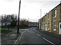
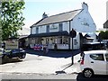
4
Springwell Road, Springwell
Looking north west.
Image: © JThomas
Taken: 18 Aug 2018
0.11 miles

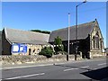
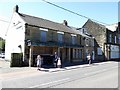
7

World War 2 posters, Springwell Community Centre
Part of display in the corridor of Springwell Community Centre at Springwell village in Gateshead for their 1940s weekend festival which includes other venues such as the exhibits of wartime memorabilia and battle demonstrations at Bowes Railway Museum Image
Image: © Andrew Curtis
Taken: 30 Jun 2018
0.19 miles

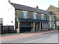
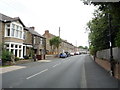
10
Former Perseverance Arms, Springwell
Little change in this derelict, rather unsuitably named pub, since 2014 Image but suitably decorated today as a bombed-out property for the Springwell 1940s weekend. It dates from the Victorian era situated close to Springwell Colliery and a large sandstone quarry.
Image: © Andrew Curtis
Taken: 30 Jun 2018
0.23 miles