IMAGES TAKEN NEAR TO
Western View, GATESHEAD, NE9 7HB
Introduction
This page details the photographs taken nearby to Western View, NE9 7HB by members of the Geograph project.
The Geograph project started in 2005 with the aim of publishing, organising and preserving representative images for every square kilometre of Great Britain, Ireland and the Isle of Man.

There are currently over 7.5m images from over14,400 individuals and you can help contribute to the project by visiting https://www.geograph.org.uk
Image Map
Images are licensed for reuse under creativecommons.org/licenses/by-sa/2.0
Notes
- Clicking on the map will re-center to the selected point.
- The higher the marker number, the further away the image location is from the centre of the postcode.
Image Listing (8 Images Found)
Images are licensed for reuse under creativecommons.org/licenses/by-sa/2.0
Image
Details
Distance
2
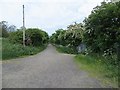
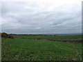
Former mineral railway, Team Colliery
Above the Team Colliery site, a former railway, now a path.
Image: © Richard Webb
Taken: 18 Jun 2013
0.12 miles
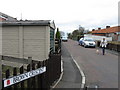
3
Old gate and fence, High Eighton
A guess: once a colliery perimeter?
Image: © Richard Webb
Taken: 18 Jun 2013
0.13 miles
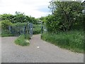
4
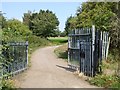
Gateway into Ravensworth Golf Club
The Ravensworth Golf Club course straddles the Angel Cycleway, a railway path.
Image: © Oliver Dixon
Taken: 26 Jul 2018
0.14 miles
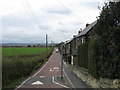
6
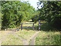
Access control on the Angel Cycleway
The Angel Cycleway follows the line of an old railway up to Wrekenton.
Image: © Oliver Dixon
Taken: 26 Jul 2018
0.19 miles
7
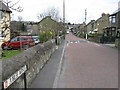
Fields SSE of Springfield Avenue, Eighton Banks
Image: © Alex McGregor
Taken: 15 Apr 2010
0.21 miles