IMAGES TAKEN NEAR TO
Wallace Gardens, GATESHEAD, NE9 7BS
Introduction
This page details the photographs taken nearby to Wallace Gardens, NE9 7BS by members of the Geograph project.
The Geograph project started in 2005 with the aim of publishing, organising and preserving representative images for every square kilometre of Great Britain, Ireland and the Isle of Man.

There are currently over 7.5m images from over14,400 individuals and you can help contribute to the project by visiting https://www.geograph.org.uk
Image Map
Images are licensed for reuse under creativecommons.org/licenses/by-sa/2.0
Notes
- Clicking on the map will re-center to the selected point.
- The higher the marker number, the further away the image location is from the centre of the postcode.
Image Listing (7 Images Found)
Images are licensed for reuse under creativecommons.org/licenses/by-sa/2.0
Image
Details
Distance
1
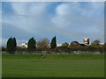
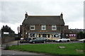
Hill Top School
It's that difficult to get a close up shot of the school due to the amount of railings around the place, it becomes difficult to know if this school is a school or a prison... For your information, it is a non-selective state special community school for girls and boys aged from 11 to 16.
Image: © Steve McShane
Taken: 5 Nov 2005
0.09 miles
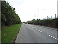
2
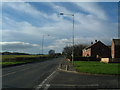
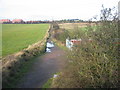
Leam Lane
This is the view up the hill of Leam Lane, formerly a Roman road known as Wrekendyke.
Image: © Steve McShane
Taken: 5 Nov 2005
0.09 miles
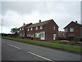
7
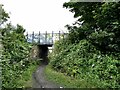
Bridge on the Bowes Railway path
The Bowes Railway was an old colliery railway which ran from Andrews House, Sunniside to coal staithes at Jarrow. Most of the length of the line has now been converted to a cycle path, designated Regional Route 11 of the National Cycle Network.
Image: © Oliver Dixon
Taken: 14 Jul 2021
0.24 miles