IMAGES TAKEN NEAR TO
Springwell Terrace, GATESHEAD, NE9 7AY
Introduction
This page details the photographs taken nearby to Springwell Terrace, NE9 7AY by members of the Geograph project.
The Geograph project started in 2005 with the aim of publishing, organising and preserving representative images for every square kilometre of Great Britain, Ireland and the Isle of Man.

There are currently over 7.5m images from over14,400 individuals and you can help contribute to the project by visiting https://www.geograph.org.uk
Image Map
Images are licensed for reuse under creativecommons.org/licenses/by-sa/2.0
Notes
- Clicking on the map will re-center to the selected point.
- The higher the marker number, the further away the image location is from the centre of the postcode.
Image Listing (5 Images Found)
Images are licensed for reuse under creativecommons.org/licenses/by-sa/2.0
Image
Details
Distance
2
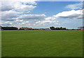
Recreation ground, Camp ground
On the outskirts of Wrekenton.
Image: © wfmillar
Taken: 3 Aug 2009
0.20 miles
4
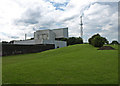
Refuse Disposal Plant, Camp Ground
Also a well organized waste recycling depot.
Image: © wfmillar
Taken: 3 Aug 2009
0.23 miles
5
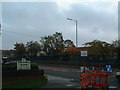
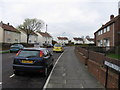
Springwell Estate
Fell Dyke Community Primary School - just like the sign says! In the foreground, a sign that has seen better days lets drivers with sharp eyesight know that they are welcome, but only if they drive carefully... so not many then, judging by some of the traffic I've seen there...
Image: © Steve McShane
Taken: 29 Oct 2005
0.25 miles