IMAGES TAKEN NEAR TO
Brampton Gardens, GATESHEAD, NE9 6PT
Introduction
This page details the photographs taken nearby to Brampton Gardens, NE9 6PT by members of the Geograph project.
The Geograph project started in 2005 with the aim of publishing, organising and preserving representative images for every square kilometre of Great Britain, Ireland and the Isle of Man.

There are currently over 7.5m images from over14,400 individuals and you can help contribute to the project by visiting https://www.geograph.org.uk
Image Map (Loading...)


Getting Data...Please wait
Leaflet Map data © OpenStreetMap
Images are licensed for reuse under creativecommons.org/licenses/by-sa/2.0
Notes
- Clicking on the map will re-center to the selected point.
- The higher the marker number, the further away the image location is from the centre of the postcode.
Image Listing (8 Images Found)
Images are licensed for reuse under creativecommons.org/licenses/by-sa/2.0
Image
Details
Distance
1
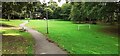
Play area and goalposts in Calderwood Park
Image: © Luke Shaw
Taken: 17 Sep 2022
0.14 miles
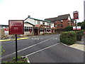
3
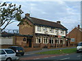
The Beacon pub
The pub lies on Beacon Lough Road.
Image: © Steve McShane
Taken: 29 Oct 2005
0.21 miles
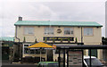
4
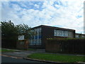
Lyndhurst Centre
The school is on Beacon Lough Road, opposite the Beacon pub
Image: © Steve McShane
Taken: 29 Oct 2005
0.21 miles
5
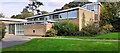
St Ninian's Church on NW side of Ivy Lane
Image: © Roger Templeman
Taken: 17 Sep 2022
0.22 miles
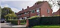
6
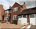
#771 Durham Road
Ordnance Survey documents indicate that a benchmark was levelled at 76.023m above Newlyn Datum on the far corner of the house
Image: © Roger Templeman
Taken: 17 Sep 2022
0.23 miles