IMAGES TAKEN NEAR TO
Beechwood Avenue, GATESHEAD, NE9 6PP
Introduction
This page details the photographs taken nearby to Beechwood Avenue, NE9 6PP by members of the Geograph project.
The Geograph project started in 2005 with the aim of publishing, organising and preserving representative images for every square kilometre of Great Britain, Ireland and the Isle of Man.

There are currently over 7.5m images from over14,400 individuals and you can help contribute to the project by visiting https://www.geograph.org.uk
Image Map (Loading...)


Getting Data...Please wait
Leaflet Map data © OpenStreetMap
Images are licensed for reuse under creativecommons.org/licenses/by-sa/2.0
Notes
- Clicking on the map will re-center to the selected point.
- The higher the marker number, the further away the image location is from the centre of the postcode.
Image Listing (11 Images Found)
Images are licensed for reuse under creativecommons.org/licenses/by-sa/2.0
Image
Details
Distance
1
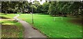
Play area and goalposts in Calderwood Park
Image: © Luke Shaw
Taken: 17 Sep 2022
0.09 miles
2
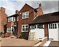
#771 Durham Road
Ordnance Survey documents indicate that a benchmark was levelled at 76.023m above Newlyn Datum on the far corner of the house
Image: © Roger Templeman
Taken: 17 Sep 2022
0.15 miles
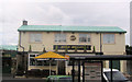
3
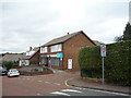
Shops on Flexbury Gardens, Harlow Green, Gateshead
Image: © JThomas
Taken: 18 Aug 2018
0.16 miles
4
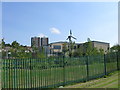
Wind Turbine, Harlow Green Community Primary School
Image: © Alex McGregor
Taken: 2 Sep 2010
0.17 miles
5
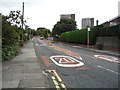
Harlow Green Lane, Harlow Green, Gateshead
Looking up the hill - north east.
Image: © JThomas
Taken: 18 Aug 2018
0.18 miles