IMAGES TAKEN NEAR TO
Dartmouth Avenue, GATESHEAD, NE9 6NW
Introduction
This page details the photographs taken nearby to Dartmouth Avenue, NE9 6NW by members of the Geograph project.
The Geograph project started in 2005 with the aim of publishing, organising and preserving representative images for every square kilometre of Great Britain, Ireland and the Isle of Man.

There are currently over 7.5m images from over14,400 individuals and you can help contribute to the project by visiting https://www.geograph.org.uk
Image Map (Loading...)


Getting Data...Please wait
Leaflet Map data © OpenStreetMap
Images are licensed for reuse under creativecommons.org/licenses/by-sa/2.0
Notes
- Clicking on the map will re-center to the selected point.
- The higher the marker number, the further away the image location is from the centre of the postcode.
Image Listing (8 Images Found)
Images are licensed for reuse under creativecommons.org/licenses/by-sa/2.0
Image
Details
Distance
1
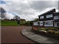
Cheddar Gardens
A street in the Chowdene area of Gateshead.
Image: © DS Pugh
Taken: 28 Apr 2020
0.06 miles
2
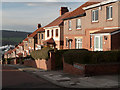
Semi-detached housing on Bideford Gardens
Bideford Gardens is a steep road of the Low Fell district of Gateshead; it overlooks the Team Valley and steam or smoke from factories of the Team Valley Trading Estate can be seen. (Bideford Gardens was the home of the photographer for many years.)
Image: © Trevor Littlewood
Taken: 24 Nov 2011
0.13 miles
3

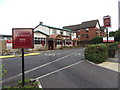
Sign for the Gold Medal, Chowdene, Gateshead
Image: © JThomas
Taken: 18 Aug 2018
0.13 miles
4
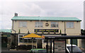
The Gold Medal, Chowdene, Gateshead
On Chowdene Bank.
Image: © JThomas
Taken: 18 Aug 2018
0.14 miles
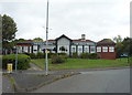
7
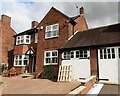
#771 Durham Road
Ordnance Survey documents indicate that a benchmark was levelled at 76.023m above Newlyn Datum on the far corner of the house
Image: © Roger Templeman
Taken: 17 Sep 2022
0.24 miles
8
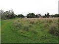
Chowdene Estate
Looking north towards Chowdene Estate on the field between the estate and the A1.
Image: © Kevin Hall
Taken: 27 Aug 2012
0.25 miles