IMAGES TAKEN NEAR TO
Carlton Terrace, GATESHEAD, NE9 6HJ
Introduction
This page details the photographs taken nearby to Carlton Terrace, NE9 6HJ by members of the Geograph project.
The Geograph project started in 2005 with the aim of publishing, organising and preserving representative images for every square kilometre of Great Britain, Ireland and the Isle of Man.

There are currently over 7.5m images from over14,400 individuals and you can help contribute to the project by visiting https://www.geograph.org.uk
Image Map
Images are licensed for reuse under creativecommons.org/licenses/by-sa/2.0
Notes
- Clicking on the map will re-center to the selected point.
- The higher the marker number, the further away the image location is from the centre of the postcode.
Image Listing (22 Images Found)
Images are licensed for reuse under creativecommons.org/licenses/by-sa/2.0
Image
Details
Distance

4
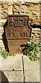
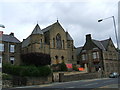
Edward VII GPO cable marker
The marker is against the wall fronting Wesley Memorial Methodist Church Image on the east side of Durham Road. See https://gpo-markers.derektp.co.uk/detail?post=332
Image: © Roger Templeman
Taken: 1 Sep 2022
0.16 miles
5
Wesley Memorial Methodist Church, east side Durham Road
Image: © Luke Shaw
Taken: 1 Sep 2022
0.16 miles
6

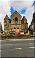
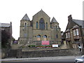
St. Helen's Church, Low Fell, Gateshead
The Parish of Saint Helen owes its existence to the large population explosion experienced by industrial centres of the nineteenth century. Until then Low Fell had been but a small village on the Southern edge of Gateshead - coal mining being the principal occupation. The opening of the Gateshead to Durham Turnpike in 1827 served to put Low Fell on the map and many of the industrialists and merchants of Gateshead and Newcastle built large houses in the area, this being followed by a steady growth in population generally. Residents faced a stiff uphill climb to the local Parish Church of St. John at the top of Sheriff Hill.
The new Parish of St. Helen was formed by combining parts of the parishes of St. Mary, Gateshead, St. John, Gateshead Fell and St. Cuthbert, Gateshead. The entire cost of the Church - £13,000 - was met by Edward Joicey of Whinney House, Low Fell who was a partner in the firm of Joicey and Co., colliery owners. The original living was in the gift of Mr.Joicey of the net annual value of £300. The Church was consecrated on 29th August 1876.
http://www.sthelenslowfell.com/church-building.php
Image: © Les Hull
Taken: 2 Mar 2011
0.16 miles
7
The Wesley Memorial Methodist Chapel
Image: © Bill Henderson
Taken: 28 Jun 2008
0.17 miles
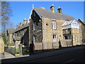
9
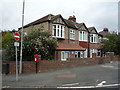
Houses on Saltwell Road South
Showing position of Postbox No. NE9 26.
Image: © JThomas
Taken: 18 Aug 2018
0.19 miles
10
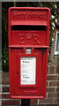
Elizabeth II postbox on Saltwell Road South
Postbox No. NE9 26.
Image: © JThomas
Taken: 18 Aug 2018
0.19 miles