IMAGES TAKEN NEAR TO
Church Road, GATESHEAD, NE9 5RH
Introduction
This page details the photographs taken nearby to Church Road, NE9 5RH by members of the Geograph project.
The Geograph project started in 2005 with the aim of publishing, organising and preserving representative images for every square kilometre of Great Britain, Ireland and the Isle of Man.

There are currently over 7.5m images from over14,400 individuals and you can help contribute to the project by visiting https://www.geograph.org.uk
Image Map
Images are licensed for reuse under creativecommons.org/licenses/by-sa/2.0
Notes
- Clicking on the map will re-center to the selected point.
- The higher the marker number, the further away the image location is from the centre of the postcode.
Image Listing (5 Images Found)
Images are licensed for reuse under creativecommons.org/licenses/by-sa/2.0
Image
Details
Distance
1

Entrance to Kells Lane Primary School
Image: © Alex McGregor
Taken: 28 Jun 2011
0.21 miles
2

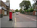
Elizabeth II postbox on Dryden Road
Postbox No. NE9 27.
See Image] for context.
Image: © JThomas
Taken: 18 Aug 2018
0.22 miles
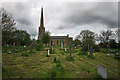
3
Dryden Road
Looking north showing position of Dryden Road
See Image] for postbox.
Image: © JThomas
Taken: 18 Aug 2018
0.22 miles
4
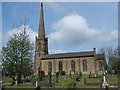
St John's Church
View from Hill Top Avenue of St John's Church at Sheriff Hill. This church was built around 1825.
Image: © Peter McDermott
Taken: 18 May 2008
0.22 miles