IMAGES TAKEN NEAR TO
Sheriff Mount, GATESHEAD, NE9 5JX
Introduction
This page details the photographs taken nearby to Sheriff Mount, NE9 5JX by members of the Geograph project.
The Geograph project started in 2005 with the aim of publishing, organising and preserving representative images for every square kilometre of Great Britain, Ireland and the Isle of Man.

There are currently over 7.5m images from over14,400 individuals and you can help contribute to the project by visiting https://www.geograph.org.uk
Image Map
Images are licensed for reuse under creativecommons.org/licenses/by-sa/2.0
Notes
- Clicking on the map will re-center to the selected point.
- The higher the marker number, the further away the image location is from the centre of the postcode.
Image Listing (11 Images Found)
Images are licensed for reuse under creativecommons.org/licenses/by-sa/2.0
Image
Details
Distance

3
Old Durham Road, Deckham
Late afternoon sun lights up terraced housing.
Image: © wfmillar
Taken: 22 Oct 2011
0.10 miles

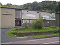
6
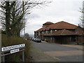
The Plough
The Plough public house in Deckham, Gateshead.
Image: © Peter McDermott
Taken: 15 Nov 2014
0.14 miles
7
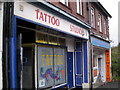
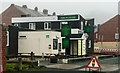
Tattoo Shop on Old Durham Road
A block of shops on Old Durham Road (B1296).
Image: © MSX
Taken: 19 Oct 2005
0.15 miles
9
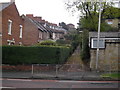
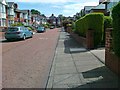
Stavordale Terrace
Off Old Durham Road, this typifies Gateshead's hilly residential areas.
Image: © MSX
Taken: 19 Oct 2005
0.15 miles
10
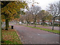
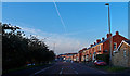
Valley Drive
Absurdly leafy dual carriageway avenue. This links Old Durham Road to Durham Road.
Image: © MSX
Taken: 19 Oct 2005
0.15 miles