IMAGES TAKEN NEAR TO
Weathercock Lane, GATESHEAD, NE9 5JD
Introduction
This page details the photographs taken nearby to Weathercock Lane, NE9 5JD by members of the Geograph project.
The Geograph project started in 2005 with the aim of publishing, organising and preserving representative images for every square kilometre of Great Britain, Ireland and the Isle of Man.

There are currently over 7.5m images from over14,400 individuals and you can help contribute to the project by visiting https://www.geograph.org.uk
Image Map (Loading...)


Getting Data...Please wait
Leaflet Map data © OpenStreetMap
Images are licensed for reuse under creativecommons.org/licenses/by-sa/2.0
Notes
- Clicking on the map will re-center to the selected point.
- The higher the marker number, the further away the image location is from the centre of the postcode.
Image Listing (21 Images Found)
Images are licensed for reuse under creativecommons.org/licenses/by-sa/2.0
Image
Details
Distance
2
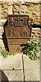
Edward VII GPO cable marker
The marker is against the wall fronting Wesley Memorial Methodist Church Image on the east side of Durham Road. See https://gpo-markers.derektp.co.uk/detail?post=332
Image: © Roger Templeman
Taken: 1 Sep 2022
0.04 miles
3
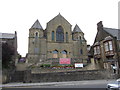
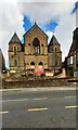
The Wesley Memorial Methodist Chapel
Image: © Bill Henderson
Taken: 28 Jun 2008
0.05 miles
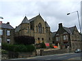
4
Wesley Memorial Methodist Church, east side Durham Road
Image: © Luke Shaw
Taken: 1 Sep 2022
0.05 miles
6

Entrance to Kells Lane Primary School
Image: © Alex McGregor
Taken: 28 Jun 2011
0.09 miles


10
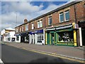
Pet supplies and Post Office
A strange combination on Beaconsfield Road.
Image: © JThomas
Taken: 18 Aug 2018
0.15 miles