IMAGES TAKEN NEAR TO
Kells Lane, GATESHEAD, NE9 5HX
Introduction
This page details the photographs taken nearby to Kells Lane, NE9 5HX by members of the Geograph project.
The Geograph project started in 2005 with the aim of publishing, organising and preserving representative images for every square kilometre of Great Britain, Ireland and the Isle of Man.

There are currently over 7.5m images from over14,400 individuals and you can help contribute to the project by visiting https://www.geograph.org.uk
Image Map
Images are licensed for reuse under creativecommons.org/licenses/by-sa/2.0
Notes
- Clicking on the map will re-center to the selected point.
- The higher the marker number, the further away the image location is from the centre of the postcode.
Image Listing (16 Images Found)
Images are licensed for reuse under creativecommons.org/licenses/by-sa/2.0
Image
Details
Distance
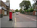
1

Elizabeth II postbox on Dryden Road
Postbox No. NE9 27.
See Image] for context.
Image: © JThomas
Taken: 18 Aug 2018
0.05 miles
2
Dryden Road
Looking north showing position of Dryden Road
See Image] for postbox.
Image: © JThomas
Taken: 18 Aug 2018
0.06 miles
3
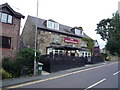
The Beaconsfield
Public house on Beaconsfield Road.
Image: © JThomas
Taken: 18 Aug 2018
0.08 miles
4

Entrance to Kells Lane Primary School
Image: © Alex McGregor
Taken: 28 Jun 2011
0.08 miles
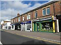
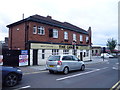
5
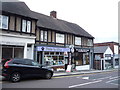
Pet supplies and Post Office
A strange combination on Beaconsfield Road.
Image: © JThomas
Taken: 18 Aug 2018
0.10 miles

7
The Cannon public house
At the junction of Beaconsfield Road and Durham Road.
Image: © JThomas
Taken: 18 Aug 2018
0.13 miles

9
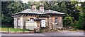
The Lodge, #27 Durham Road at Mulberry Park junction
Image: © Luke Shaw
Taken: 1 Sep 2022
0.16 miles