IMAGES TAKEN NEAR TO
Durham Road, GATESHEAD, NE9 5AH
Introduction
This page details the photographs taken nearby to Durham Road, NE9 5AH by members of the Geograph project.
The Geograph project started in 2005 with the aim of publishing, organising and preserving representative images for every square kilometre of Great Britain, Ireland and the Isle of Man.

There are currently over 7.5m images from over14,400 individuals and you can help contribute to the project by visiting https://www.geograph.org.uk
Image Map
Images are licensed for reuse under creativecommons.org/licenses/by-sa/2.0
Notes
- Clicking on the map will re-center to the selected point.
- The higher the marker number, the further away the image location is from the centre of the postcode.
Image Listing (46 Images Found)
Images are licensed for reuse under creativecommons.org/licenses/by-sa/2.0
Image
Details
Distance
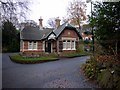
1

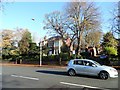
Gates to Heathfield House, Gateshead
Heathfield House on Durham Road in the Low Fell area of the town was built in 1856. The house, including the imposing gates seen here, was designed by John Wardle, who also designed The Hancock Museum in Newcastle. Many wealthy industrialists built mansions in Low Fell in the middle of the 19th century, away from the crowded town centre.
Image: © Robert Graham
Taken: 18 Nov 2019
0.05 miles
2
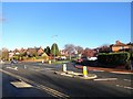
Bottom of Valley Drive, Low Fell
This is the junction of Valley Drive with Durham Road. As can be seen, this is a rather affluent area of Gateshead.
Image: © Robert Graham
Taken: 18 Nov 2019
0.06 miles
3
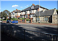
Semi-detached housing in Gateshead
Substantial semi-detached houses on the east side of Durham Road in the Low Fell district of Gateshead. The small, stone built cottage is adjacent to a large property and was perhaps a gatehouse for it.
Image: © Trevor Littlewood
Taken: 9 Oct 2013
0.07 miles
4
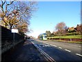
Looking north along Durham Road, Gateshead
This is in the Low Fell area of the town. Durham Road is the main road south through the suburbs. A lot of bus routes follow this road. Ashfield Gardens is on the right.
Image: © Robert Graham
Taken: 18 Nov 2019
0.12 miles
5

Benchmark on wall on west side of Durham Road opposite #289
Ordnance Survey cut mark benchmark levelled at 87.624m above Newlyn Datum verified 1962
Image: © Roger Templeman
Taken: 1 Sep 2022
0.14 miles
6
East Lodge, Saltwell Park
By the entrance on East Park Road.
Image: © Andrew Curtis
Taken: 13 Nov 2009
0.14 miles
7
Large houses on Durham Road, Gateshead
This is the Low Fell area of the town, and has been a more affluent area since development started in the 19th century.
Image: © Robert Graham
Taken: 18 Nov 2019
0.15 miles
8
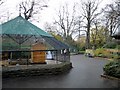
Aviaries, Saltwell Park
The two aviaries were restored to their original state and house a variety of ornamental birds and small mammals. A big attraction for child visitors.
Image: © Andrew Curtis
Taken: 13 Nov 2009
0.16 miles
9
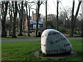
'The Language Stone', Saltwell Park
Sculpture in white marble by Gordon Young (b. 1952, Carlisle).
The stone was originally from Italy but laid on the seabed off Plymouth for 150 years after shipwreck. The text on the stone in several languages express the feeling of love. The piece was commissioned in 2006 for the Gateshead Sculpture Festival.
Saltwell Towers is visible behind Image
Image: © Andrew Curtis
Taken: 27 Nov 2009
0.16 miles
10
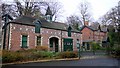
Stable Block, Saltwell Park
Built around 1871 in a similar style to the mansion Image Red brick with white brick quoins and dressings and polychrome frieze. Hipped slate roof (a roof having sloping ends as well as sloping sides) with 2 gabled dormers, central spire, and a shelter for a bell on the west (left) side. There is a central segmental arched doorway with carriage doors on its right.
Grade II Listed Building http://www.heritagegateway.org.uk/Gateway/Results_Single.aspx?resourceID=5&uid=1277773
The building has been restored and is now used as an education area by schools, colleges and community groups.
Image: © Andrew Curtis
Taken: 13 Nov 2009
0.16 miles