IMAGES TAKEN NEAR TO
Durham Road, GATESHEAD, NE9 5AD
Introduction
This page details the photographs taken nearby to Durham Road, NE9 5AD by members of the Geograph project.
The Geograph project started in 2005 with the aim of publishing, organising and preserving representative images for every square kilometre of Great Britain, Ireland and the Isle of Man.

There are currently over 7.5m images from over14,400 individuals and you can help contribute to the project by visiting https://www.geograph.org.uk
Image Map
Images are licensed for reuse under creativecommons.org/licenses/by-sa/2.0
Notes
- Clicking on the map will re-center to the selected point.
- The higher the marker number, the further away the image location is from the centre of the postcode.
Image Listing (54 Images Found)
Images are licensed for reuse under creativecommons.org/licenses/by-sa/2.0
Image
Details
Distance
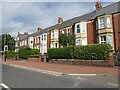
1
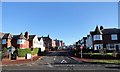
Summerfield Road, Gateshead
This is the junction of Summerfield Road at its western end with Durham Road. The houses here are probably 1930's, but older terraced housing is evident higher up the bank.
Image: © Robert Graham
Taken: 18 Nov 2019
0.03 miles
2
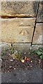
Benchmark on wall fronting #53/54 William Wailes Walk
Ordnance Survey cut mark benchmark levelled at 88.215m above Newlyn Datum verified 1962
Image: © Roger Templeman
Taken: 1 Sep 2022
0.04 miles
3
Houses of William Wailes Walk on west side of Durham Road
There is an Ordnance Survey benchmark Image on the high stone wall at its junction with the lower wall
Image: © Roger Templeman
Taken: 1 Sep 2022
0.05 miles
4
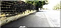
Stone wall between Durham Road and North Dene Drive
There is an Ordnance Survey benchmark Image on a stone in the wall, second above pavement and third from left hand edge of image
Image: © Roger Templeman
Taken: 1 Sep 2022
0.05 miles
5

Benchmark on wall on west side of Durham Road opposite #289
Ordnance Survey cut mark benchmark levelled at 87.624m above Newlyn Datum verified 1962
Image: © Roger Templeman
Taken: 1 Sep 2022
0.09 miles
6
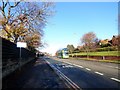
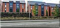
Looking north along Durham Road, Gateshead
This is in the Low Fell area of the town. Durham Road is the main road south through the suburbs. A lot of bus routes follow this road. Ashfield Gardens is on the right.
Image: © Robert Graham
Taken: 18 Nov 2019
0.11 miles
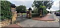
7
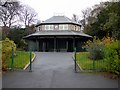
The Almond Pavilion, Saltwell Park
The Almond Pavilion has been restored to replicate the original appearance of the 1881 building. It houses a refreshment kiosk and toilets open in the summer months.
Image: © Andrew Curtis
Taken: 13 Nov 2009
0.11 miles
9
Junction of Enfield Road with Durham Road
In the Saltwell area of Gateshead. Durham Road is the main north south road through this part of the town. Enfield Road leads west to Saltwell Park.
Image: © Robert Graham
Taken: 18 Nov 2019
0.12 miles
10
Entrance to Lindum House, #219 Durham Road
There is an Ordnance Survey benchmark Image on the wall pier at the far side of the gateway
Image: © Roger Templeman
Taken: 1 Sep 2022
0.13 miles