IMAGES TAKEN NEAR TO
Westbourne Avenue, GATESHEAD, NE8 4NP
Introduction
This page details the photographs taken nearby to Westbourne Avenue, NE8 4NP by members of the Geograph project.
The Geograph project started in 2005 with the aim of publishing, organising and preserving representative images for every square kilometre of Great Britain, Ireland and the Isle of Man.

There are currently over 7.5m images from over14,400 individuals and you can help contribute to the project by visiting https://www.geograph.org.uk
Image Map
Images are licensed for reuse under creativecommons.org/licenses/by-sa/2.0
Notes
- Clicking on the map will re-center to the selected point.
- The higher the marker number, the further away the image location is from the centre of the postcode.
Image Listing (35 Images Found)
Images are licensed for reuse under creativecommons.org/licenses/by-sa/2.0
Image
Details
Distance
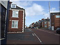
1
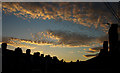
Tyne-side chimneys
Typical terraced flats in this area give a roof top scene at sunset.
Image: © wfmillar
Taken: 2 Jul 2008
0.02 miles

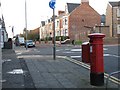
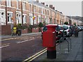
6
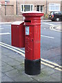
Edward VII postbox, Brinkburn Avenue
Image: © Mike Quinn
Taken: 3 Nov 2009
0.10 miles
7
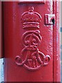
Edward VII postbox, Brinkburn Avenue - royal cipher
See Image
Image: © Mike Quinn
Taken: 3 Nov 2009
0.10 miles