IMAGES TAKEN NEAR TO
Granville Street, GATESHEAD, NE8 4EH
Introduction
This page details the photographs taken nearby to Granville Street, NE8 4EH by members of the Geograph project.
The Geograph project started in 2005 with the aim of publishing, organising and preserving representative images for every square kilometre of Great Britain, Ireland and the Isle of Man.

There are currently over 7.5m images from over14,400 individuals and you can help contribute to the project by visiting https://www.geograph.org.uk
Image Map
Images are licensed for reuse under creativecommons.org/licenses/by-sa/2.0
Notes
- Clicking on the map will re-center to the selected point.
- The higher the marker number, the further away the image location is from the centre of the postcode.
Image Listing (67 Images Found)
Images are licensed for reuse under creativecommons.org/licenses/by-sa/2.0
Image
Details
Distance

4
Ann Street Garage
Ann Street itself is several hundred yards away from here
Image: © Roger Smith
Taken: 2 Jun 2009
0.07 miles
8

Edward VII GPO cable marker against boundary wall of #69 Durham Road
See https://gpo-markers.derektp.co.uk/detail?post=257 for information
Image: © Roger Templeman
Taken: 1 Sep 2022
0.11 miles
10
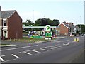
BP Garage on Old Durham Road
Petrol station with Londis convenience store on the B1296.
Image: © Oliver Dixon
Taken: 26 Jul 2018
0.12 miles