IMAGES TAKEN NEAR TO
Raby Street, GATESHEAD, NE8 4AG
Introduction
This page details the photographs taken nearby to Raby Street, NE8 4AG by members of the Geograph project.
The Geograph project started in 2005 with the aim of publishing, organising and preserving representative images for every square kilometre of Great Britain, Ireland and the Isle of Man.

There are currently over 7.5m images from over14,400 individuals and you can help contribute to the project by visiting https://www.geograph.org.uk
Image Map
Images are licensed for reuse under creativecommons.org/licenses/by-sa/2.0
Notes
- Clicking on the map will re-center to the selected point.
- The higher the marker number, the further away the image location is from the centre of the postcode.
Image Listing (52 Images Found)
Images are licensed for reuse under creativecommons.org/licenses/by-sa/2.0
Image
Details
Distance
1
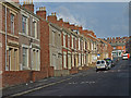
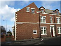
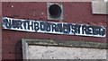
Northbourne Street, Gateshead
Typical Tyneside flats.
Image: © wfmillar
Taken: 21 Mar 2008
0.04 miles
2
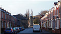
Northbourne Street, Gateshead
Typical terraced housing. Gateshead's war memorial centre frame.
Image: © wfmillar
Taken: 25 Dec 2013
0.05 miles
3
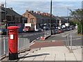
Old Durham Road, Deckham
Shows the location of Image
Image: © Mike Quinn
Taken: 10 Sep 2009
0.06 miles
4
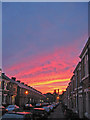
Northbourne Street, Gateshead.
Spectacular sunset. Mostly flats in this typical Tyne-side street.
Image: © wfmillar
Taken: 11 Oct 2008
0.06 miles
6
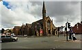
St Mark's Methodist Church at Durham Road / Shipcote Terrace junction
Image: © Luke Shaw
Taken: 1 Sep 2022
0.07 miles
7
Northbourne Street, Gateshead
End of terrace.
Image: © wfmillar
Taken: 21 Mar 2008
0.08 miles
8
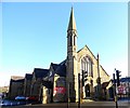
St Mark's Methodist Church, Gateshead
On the junction of Shipcote Terrace with Durham Road. The church was built in 1906.
Image: © Robert Graham
Taken: 18 Nov 2019
0.08 miles
10
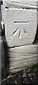
Benchmark on Shipcote Terrace face of #129 Durham Road
Ordnance Survey cut mark benchmark levelled at 81.315m above Newlyn Datum verified 1962
Image: © Roger Templeman
Taken: 1 Sep 2022
0.09 miles