IMAGES TAKEN NEAR TO
Chaucer Close, GATESHEAD, NE8 3NQ
Introduction
This page details the photographs taken nearby to Chaucer Close, NE8 3NQ by members of the Geograph project.
The Geograph project started in 2005 with the aim of publishing, organising and preserving representative images for every square kilometre of Great Britain, Ireland and the Isle of Man.

There are currently over 7.5m images from over14,400 individuals and you can help contribute to the project by visiting https://www.geograph.org.uk
Image Map
Images are licensed for reuse under creativecommons.org/licenses/by-sa/2.0
Notes
- Clicking on the map will re-center to the selected point.
- The higher the marker number, the further away the image location is from the centre of the postcode.
Image Listing (19 Images Found)
Images are licensed for reuse under creativecommons.org/licenses/by-sa/2.0
Image
Details
Distance
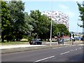
1
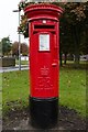
Elizabeth II postbox, Wordsworth Street
Situated between the junctions with Milton Square and Sunderland Road.
Image: © Mark Anderson
Taken: 26 Oct 2019
0.13 miles
2
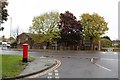
Wordsworth Street approaching Sunderland Road
A closer view of the postbox can be seen here: Image
Image: © Mark Anderson
Taken: 26 Oct 2019
0.13 miles
3
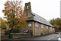
St James and St Bede Church, Wordsworth Street
Image: © Mark Anderson
Taken: 26 Oct 2019
0.15 miles
4
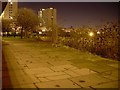
Looking towards Lindisfarne Flats from beneath Gateshead Highway
Near the town centre.
Image: © Stephen Sweeney
Taken: 8 Jan 2009
0.17 miles
5
Chad House
Modern apartment block on Sunderland Road.
Image: © Oliver Dixon
Taken: 26 Jul 2018
0.18 miles
6
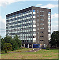
Chad House, Sunderland Road, Gateshead
One of eight office blocks intended as part of the ambitious Tynegate Office Precinct. Only three were realised. The blocks were designed by Hubbard Ford & Partners and built in 1967-70.
At the time, all three looked in decent condition and were at least partly occupied.
Image: © Stephen Richards
Taken: 16 Aug 2012
0.19 miles
7
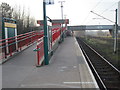
Gateshead Stadium Metro station, Tyne & Wear
Opened in 1981 by the Tyne & Wear Metro on the line from Newcastle to Sunderland.
View north west towards Gateshead and Newcastle. The lines on the right are the 'heavy' rail lines from Newcastle Central to Sunderland.
Image: © Nigel Thompson
Taken: 24 Mar 2012
0.20 miles
8
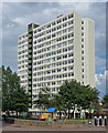
Abbot Court, Lindisfarne Drive, Gateshead
One of three sixteen-storey slabs built as the Chandless Estate of 1957-73.
They were among Gateshead's tallest buildings, but are not any longer as the whole estate was demolished in 2013. This is quite surprising given that it looked spick and span in 2012.
Image: © Stephen Richards
Taken: 16 Aug 2012
0.21 miles
9
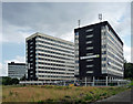
Tynegate Office Precinct, Sunderland Road, Gateshead
Eight office blocks were intended but only three were realised - Aidan, Bede and Chad Houses. The blocks were designed by Hubbard Ford & Partners and built in 1967-70.
At the time, all three looked in decent condition and were at least partly occupied.
Image: © Stephen Richards
Taken: 16 Aug 2012
0.21 miles
10
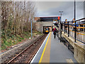
Tyne and Wear Metro, Gateshead Stadium Station
Looking northwards along platform 2 at Gateshead Stadium Metro station which is named after the nearby Gateshead International Stadium. The station opened in 1981, as part of the third phase of the Metro system.
Image: © David Dixon
Taken: 24 Mar 2016
0.21 miles