IMAGES TAKEN NEAR TO
Sanderson Villas, GATESHEAD, NE8 3BU
Introduction
This page details the photographs taken nearby to Sanderson Villas, NE8 3BU by members of the Geograph project.
The Geograph project started in 2005 with the aim of publishing, organising and preserving representative images for every square kilometre of Great Britain, Ireland and the Isle of Man.

There are currently over 7.5m images from over14,400 individuals and you can help contribute to the project by visiting https://www.geograph.org.uk
Image Map
Images are licensed for reuse under creativecommons.org/licenses/by-sa/2.0
Notes
- Clicking on the map will re-center to the selected point.
- The higher the marker number, the further away the image location is from the centre of the postcode.
Image Listing (29 Images Found)
Images are licensed for reuse under creativecommons.org/licenses/by-sa/2.0
Image
Details
Distance
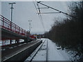
1
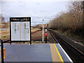
Gateshead Stadium Metro Station
The southern end of the island platform at the Gateshead Stadium Metro station which is named after the nearby Gateshead International Stadium. The station opened in 1981, as part of the third phase of the Metro system.
Image: © David Dixon
Taken: 24 Mar 2016
0.06 miles
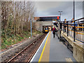
2
Gateshead Stadium Metro Station
On the Tyne and Wear Metro System. Viewed from Sunderland Road.
Image: © Stephen Sweeney
Taken: 8 Jan 2009
0.06 miles
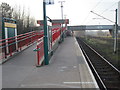
3
Tyne and Wear Metro, Gateshead Stadium Station
Looking northwards along platform 2 at Gateshead Stadium Metro station which is named after the nearby Gateshead International Stadium. The station opened in 1981, as part of the third phase of the Metro system.
Image: © David Dixon
Taken: 24 Mar 2016
0.07 miles
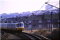
4
Gateshead Stadium Metro station, Tyne & Wear
Opened in 1981 by the Tyne & Wear Metro on the line from Newcastle to Sunderland.
View north west towards Gateshead and Newcastle. The lines on the right are the 'heavy' rail lines from Newcastle Central to Sunderland.
Image: © Nigel Thompson
Taken: 24 Mar 2012
0.07 miles
5
View from Gateshead Stadium Metro station
This photograph shows the north-bound railway track of the Metro system as it passes through the station for Gateshead stadium. The picture was taken looking in a south-westerly direction along the track towards Felling.
Image: © Philip Barker
Taken: 2 Jan 2010
0.07 miles
6
Tyne & Wear Metro approaching Gateshead Stadium
Image: © Malc McDonald
Taken: 20 Feb 1985
0.08 miles
7
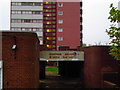
Browning Square
These tower blocks have their own mini-shopping precinct.
Image: © MSX
Taken: 28 Oct 2005
0.12 miles
8
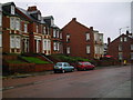
Proud Terracing on Sunderland Road
Across the road from all the demolition is this excellent example of Tyneside Terracing.
Image: © MSX
Taken: 28 Oct 2005
0.12 miles
9
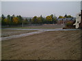
Flattened Neighbourhood
The extent of the demolition is visible here.
Image: © MSX
Taken: 28 Oct 2005
0.12 miles
10
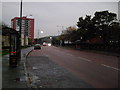
Sundeland Road (Facing East)
The Bankies are visible at the end of this stretch of Sunderland Road.
Image: © MSX
Taken: 28 Oct 2005
0.12 miles