IMAGES TAKEN NEAR TO
Jubilee Court, GATESHEAD, NE8 2EQ
Introduction
This page details the photographs taken nearby to Jubilee Court, NE8 2EQ by members of the Geograph project.
The Geograph project started in 2005 with the aim of publishing, organising and preserving representative images for every square kilometre of Great Britain, Ireland and the Isle of Man.

There are currently over 7.5m images from over14,400 individuals and you can help contribute to the project by visiting https://www.geograph.org.uk
Image Map (26 Images)


Getting Data...Please wait
Leaflet Map data © OpenStreetMap
Images are licensed for reuse under creativecommons.org/licenses/by-sa/2.0
Notes
- Clicking on the map will re-center to the selected point.
- The higher the marker number, the further away the image location is from the centre of the postcode.
Image Listing (26 Images Found)
Images are licensed for reuse under creativecommons.org/licenses/by-sa/2.0
Image
Details
Distance
1
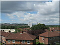
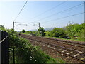
Houses at Temple Green, Gateshead
Looking west over houses from the East Coast Mainline to two tower blocks in the adjacent square west - Eslington Court [L] and Redheugh Court [R]. See Image and Image The white roof on the left is that of Astrofade Ltd., who make and install rooflights and glazing systems.
Image: © M J Richardson
Taken: 3 Jul 2023
0.02 miles
2
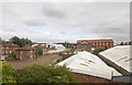
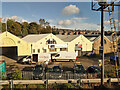
Astrofade Ltd, Kyle Road
Looking SSE over the roof of the Astrofade factory http://www.astrofade.co.uk/ in Kyle Road from a passing train.
Image: © David P Howard
Taken: 29 Aug 2013
0.06 miles
4
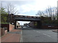
Bensham Station (remains)
View westward of remnants of Up side station buildings; ex-NER East Coast Main Line, Newcastle - Darlington - York etc. This 'suburban' station had been closed long before, on 5/4/54.
Image: © Ben Brooksbank
Taken: 10 May 1965
0.13 miles
5
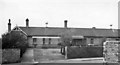
Bensham railway station (site), Tyne & Wear
Opened in 1892 by the North Eastern Railway on the line from Newcastle to Durham, this station closed to passengers in 1954.
View south towards Low Fell and Durham. The station had two parallel wooden platforms with the main building being just out of view on the extreme left. No trace apparently remains.
Image: © Nigel Thompson
Taken: 29 May 2021
0.13 miles
6

Former warehouse on Lobley Hill Road
In the Bensham area of Gateshead. This building is now a car repair centre, but was built as a warehouse for Finney's Seed Merchants, a company which closed, I think, in the 1960's.
Image: © Robert Graham
Taken: 18 Nov 2019
0.15 miles
7
Northern Floorcraft & Interiors Limited, Gateshead
Off Lobley Hill Road.
Image: © Robin Webster
Taken: 18 Oct 2019
0.15 miles
8
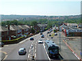
Lobley Hill Road
Viewed from a passing train headed for Newcastle.
Image: © Mary and Angus Hogg
Taken: 29 Jun 2018
0.16 miles
9

Gateshead Tower Blocks
Derwent Tower (AKA the Dunston Rocket) flanked by Redheugh Court and Eslington Court in the foreground silhouetted by the setting sun.
Image: © Craig Allan
Taken: 23 Aug 2007
0.16 miles
10
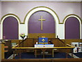
Victoria Road Methodist Church, Gateshead
Victoria Road Methodist Church, Teams, Gateshead (interior)
Image: © ian soulsby
Taken: 14 Sep 2009
0.16 miles