IMAGES TAKEN NEAR TO
High Street, GATESHEAD, NE8 1EQ
Introduction
This page details the photographs taken nearby to High Street, NE8 1EQ by members of the Geograph project.
The Geograph project started in 2005 with the aim of publishing, organising and preserving representative images for every square kilometre of Great Britain, Ireland and the Isle of Man.

There are currently over 7.5m images from over14,400 individuals and you can help contribute to the project by visiting https://www.geograph.org.uk
Image Map
Images are licensed for reuse under creativecommons.org/licenses/by-sa/2.0
Notes
- Clicking on the map will re-center to the selected point.
- The higher the marker number, the further away the image location is from the centre of the postcode.
Image Listing (130 Images Found)
Images are licensed for reuse under creativecommons.org/licenses/by-sa/2.0
Image
Details
Distance
1
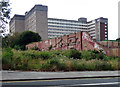
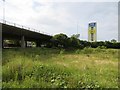
Derelict land, High Street, Gateshead
Not the best omen, on the high street. Alternatively, one could look upon it as a small nature reserve.
Though it looks like an office block, behind is a big block of flats, Regent Court, built in 1958.
Image: © Stephen Richards
Taken: 16 Aug 2012
0.03 miles
2
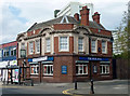
Former Moon & Sixpence, High Street, Gateshead
Yet another vanquished pub, in another life the British Lion but now bereft of roar.
Behind is Warwick Court (Image]).
Image: © Stephen Richards
Taken: 16 Aug 2012
0.04 miles
3
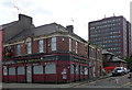
The Blue Bell, High Street, Gateshead
Decent little early C20th pub, polished granite ground floor, brick and stone above.
A sign advertised "a pub business to let", presumably this one.
Image: © Stephen Richards
Taken: 16 Aug 2012
0.05 miles
4
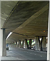
Gateshead Highway, Gateshead
Lots of lovely concrete. The supports taper and the whole effect is quite dramatic.
Image: © Stephen Richards
Taken: 16 Aug 2012
0.10 miles
5
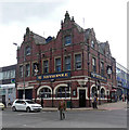
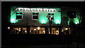
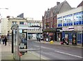
The Metropole, High Street, Gateshead
Big Victorian pub, by William Hope, 1896. Two ornate gables, but the dark brick gives it a slightly dour look. On the up-side, as the sign advertises, it is open all day every day.
Originally it had a theatre too.
Image: © Stephen Richards
Taken: 16 Aug 2012
0.10 miles
6
Warwick Court, Warwick Street, Gateshead
Flats, though it looks like offices. Probably dating from the 1970s.
The police station is next door.
Image: © Stephen Richards
Taken: 16 Aug 2012
0.10 miles
7
Site awaiting development, Gateshead
The elevated road is heading towards the Tyne Bridge and Newcastle. Mid 20th century maps show a school here and probably housing as well.
Image: © Richard Webb
Taken: 18 Jun 2013
0.10 miles
9
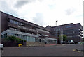
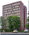
Magistrates' Court and police station, Warwick Street, Gateshead
Evidently built as a single complex, I guess in the 1970s, windows recessed in bands behind dark red brick. The police station is the taller block behind.
Image: © Stephen Richards
Taken: 16 Aug 2012
0.11 miles