IMAGES TAKEN NEAR TO
Denewell Avenue, NEWCASTLE UPON TYNE, NE7 7YA
Introduction
This page details the photographs taken nearby to Denewell Avenue, NE7 7YA by members of the Geograph project.
The Geograph project started in 2005 with the aim of publishing, organising and preserving representative images for every square kilometre of Great Britain, Ireland and the Isle of Man.

There are currently over 7.5m images from over14,400 individuals and you can help contribute to the project by visiting https://www.geograph.org.uk
Image Map
Images are licensed for reuse under creativecommons.org/licenses/by-sa/2.0
Notes
- Clicking on the map will re-center to the selected point.
- The higher the marker number, the further away the image location is from the centre of the postcode.
Image Listing (33 Images Found)
Images are licensed for reuse under creativecommons.org/licenses/by-sa/2.0
Image
Details
Distance
1
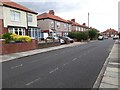
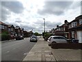
Westlands, High Heaton, Newcastle upon Tyne
A residential street in the High Heaton part of Newcastle. Semi-detached houses line both sides of the street.
Image: © Graham Robson
Taken: 30 Jun 2020
0.04 miles
2
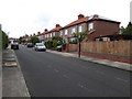
Eastlands, High Heaton, Newcastle upon Tyne
A residential street with semi detached houses on both sides in High Heaton.
Image: © Graham Robson
Taken: 30 Jun 2020
0.07 miles
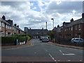
3
Jesmond Park West, High Heaton, Newcastle upon Tyne
A residential street consisting mainly of semi detached houses in the High Heaton part of Newcastle.
Image: © Graham Robson
Taken: 9 Apr 2020
0.09 miles
4
Southlands, High Heaton, Newcastle upon Tyne
A residential street lined with semi detached brick built houses in the High Heaton part of Newcastle.
Image: © Graham Robson
Taken: 1 May 2020
0.10 miles
5
View down Jesmond Park West
Suburban street in High Heaton, Newcastle.
Image: © Robert Graham
Taken: 15 Jul 2024
0.11 miles
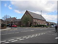
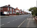
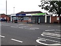
8
Newton Road
Looking East along this short shopping parade.
Image: © David Clark
Taken: 18 Sep 2013
0.14 miles
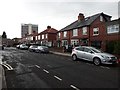
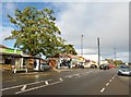
9
A pair of shops on Newton Road, Newcastle upon Tyne
A florists and physiotherapists occupying shop units on the north side of Newton Road in High Heaton.
Image: © Graham Robson
Taken: 30 Jun 2020
0.15 miles
10
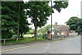
Paddy Freeman's Park
This little park in High Heaton is adjacent to Jesmond Dene, and stands beside Freeman Road. It takes its name from Patrick Freeman, known as Paddy, who farmed here in 1795. The family farmed here for many years in the 18th and 19th centuries. Although now deep within the suburbs of Newcastle, this was countryside in those days.
Image: © Robert Graham
Taken: 15 Jul 2024
0.15 miles