IMAGES TAKEN NEAR TO
Carnoustie Close, NEWCASTLE UPON TYNE, NE7 7TQ
Introduction
This page details the photographs taken nearby to Carnoustie Close, NE7 7TQ by members of the Geograph project.
The Geograph project started in 2005 with the aim of publishing, organising and preserving representative images for every square kilometre of Great Britain, Ireland and the Isle of Man.

There are currently over 7.5m images from over14,400 individuals and you can help contribute to the project by visiting https://www.geograph.org.uk
Image Map
Images are licensed for reuse under creativecommons.org/licenses/by-sa/2.0
Notes
- Clicking on the map will re-center to the selected point.
- The higher the marker number, the further away the image location is from the centre of the postcode.
Image Listing (21 Images Found)
Images are licensed for reuse under creativecommons.org/licenses/by-sa/2.0
Image
Details
Distance
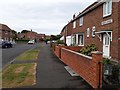
1
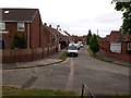
Fairville Crescent, High Heaton, Newcastle upon Tyne
An estate of terraced houses in the High Heaton part of Newcastle.
Image: © Graham Robson
Taken: 17 May 2020
0.03 miles
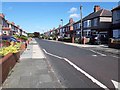
2
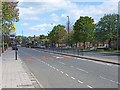
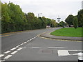
Benton Road
Benton Road (A188) is a busy south-north thoroughfare through the north-east suburbs of Newcastle. Looking towards the northern end of the central reservation.
Image: © Oliver Dixon
Taken: 16 May 2012
0.08 miles
3
Fairways Avenue, Longbenton
A residential street in Longbenton.
Image: © Graham Robson
Taken: 4 Jun 2020
0.09 miles
4
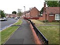
Manor Grove
Suburban street of Benton Road.
Image: © Oliver Dixon
Taken: 16 May 2012
0.10 miles
5
Fairways Avenue, Longbenton
A curving residential street in Longbenton.
Image: © Graham Robson
Taken: 4 Jun 2020
0.10 miles
6
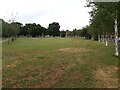
Playing field, Fairways Avenue, Longbenton
A playing field alongside Fairways Avenue in Longbenton.
Image: © Graham Robson
Taken: 4 Jun 2020
0.13 miles
7
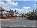
The Drive, High Heaton, Newcastle upon Tyne
A residential street in the High Heaton part of Newcastle. Rows of near identical semi detached houses stand on both sides of the street.
Image: © Graham Robson
Taken: 24 May 2020
0.13 miles
8
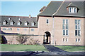
University of Newcastle upon Tyne, Henderson Hall
Image: © P Gaskell
Taken: Unknown
0.15 miles
10
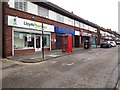
Shops, Four Lane Ends, Newcastle upon Tyne
A terrace of shops near the busy Four Lane Ends junction. The businesses include hairdressers, takeaways, a pharmacy, opticians, a bank and others.
Image: © Graham Robson
Taken: 4 Jul 2020
0.19 miles