IMAGES TAKEN NEAR TO
Patterdale Gardens, NEWCASTLE UPON TYNE, NE7 7QX
Introduction
This page details the photographs taken nearby to Patterdale Gardens, NE7 7QX by members of the Geograph project.
The Geograph project started in 2005 with the aim of publishing, organising and preserving representative images for every square kilometre of Great Britain, Ireland and the Isle of Man.

There are currently over 7.5m images from over14,400 individuals and you can help contribute to the project by visiting https://www.geograph.org.uk
Image Map
Images are licensed for reuse under creativecommons.org/licenses/by-sa/2.0
Notes
- Clicking on the map will re-center to the selected point.
- The higher the marker number, the further away the image location is from the centre of the postcode.
Image Listing (23 Images Found)
Images are licensed for reuse under creativecommons.org/licenses/by-sa/2.0
Image
Details
Distance
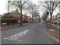
1
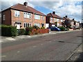
Patterdale Gardens, High Heaton, Newcastle upon Tyne
Semi-detached houses in High Heaton.
Image: © Graham Robson
Taken: 23 Jun 2020
0.01 miles
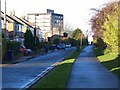
2
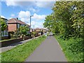
Cycleway along the Coxlodge Waggonway
The Coxlodge Waggonway ran nearly 8 km from Coxlodge to the west of Gosforth down to the River Tyne at Wallsend. In the early years of the 20th century it was used for a passenger tramway. Today about 2.5km have been converted into a foot- and cycleway running south-east from the North Gosforth roundabouts.
Image: © Oliver Dixon
Taken: 16 May 2012
0.07 miles
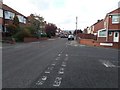
3
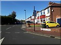
Cloverdale Gardens, High Heaton, Newcastle upon Tyne
A residential street in the High Heaton area of Newcastle.
Image: © Graham Robson
Taken: 5 May 2020
0.08 miles
4

Freeman Hospital Car Park
Freeman Hospital is one of the UK's leading Cardiology research and treatment centres.
Here is where they park the cars.
Image: © MSX
Taken: 9 Oct 2005
0.09 miles
5
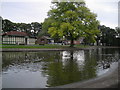
Paddy Freeman's Lake
Part of the ever popular and well maintained Paddy Freeman's park, located on the Eastern verge of Jesmond Dene.
Image: © MSX
Taken: 9 Oct 2005
0.09 miles
6
Coxlodge Waggonway
The Coxlodge Waggonway ran nearly 8 km from Coxlodge to the west of Gosforth down to the River Tyne at Wallsend. In the early years of the 20th century it was used for a passenger tramway. Today about 3 km have been converted into a foot- and cycleway. Here the cycleway runs adjacent to Whitton Place. One of the blocks of the Freeman Hospital can be seen in the background.
Image: © Oliver Dixon
Taken: 4 Dec 2013
0.11 miles
7
Jennifer Grove, High Heaton, Newcastle upon Tyne
A residential street in the High Heaton area of Newcastle. The estate contains a large number of homogeneous semi-detached houses.
Image: © Graham Robson
Taken: 17 Apr 2020
0.12 miles
8
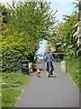
Cycling the dog
Seen on the cycleway which follows the Coxlodge Waggonway. The Coxlodge Waggonway ran nearly 8 km from Coxlodge to the west of Gosforth down to the River Tyne at Wallsend. In the early years of the 20th century it was used for a passenger tramway. Today about 2.5km have been converted into a foot- and cycleway running south-east from the North Gosforth roundabouts.
Image: © Oliver Dixon
Taken: 16 May 2012
0.15 miles
9
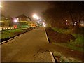
Public path in Newcastle
Passes between the HM Revenue and Customs buildings and the Freeman Hospital.
Image: © Stephen Sweeney
Taken: 15 Jan 2009
0.15 miles
10
Cleveland Gardens, High Heaton, Newcastle upon Tyne
A residential street in the High Heaton part of Newcastle. The area contains several long lines of very similar semi detached houses.
Image: © Graham Robson
Taken: 17 Apr 2020
0.16 miles