IMAGES TAKEN NEAR TO
Red Hall Drive, NEWCASTLE UPON TYNE, NE7 7LJ
Introduction
This page details the photographs taken nearby to Red Hall Drive, NE7 7LJ by members of the Geograph project.
The Geograph project started in 2005 with the aim of publishing, organising and preserving representative images for every square kilometre of Great Britain, Ireland and the Isle of Man.

There are currently over 7.5m images from over14,400 individuals and you can help contribute to the project by visiting https://www.geograph.org.uk
Image Map
Images are licensed for reuse under creativecommons.org/licenses/by-sa/2.0
Notes
- Clicking on the map will re-center to the selected point.
- The higher the marker number, the further away the image location is from the centre of the postcode.
Image Listing (19 Images Found)
Images are licensed for reuse under creativecommons.org/licenses/by-sa/2.0
Image
Details
Distance
1

The Lochside, Red Hall Drive
A large pub on the corner of Red Hall Drive and Warwick Hall Drive.
Image: © Graham Robson
Taken: 20 Mar 2020
0.04 miles
2
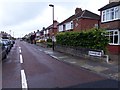
Longridge Avenue, Heaton, Newcastle upon Tyne
A street in the residential area of Heaton with rows of semi-detached houses on both sides.
Image: © Graham Robson
Taken: 10 Jun 2020
0.04 miles
3
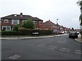
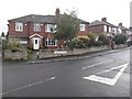
Vancouver Drive, High Heaton, Newcastle upon Tyne
A residential street with semi-detached houses on both sides.
Image: © Graham Robson
Taken: 19 Jun 2020
0.08 miles
4
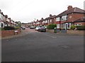
Sheffield Drive, High Heaton, Newcastle upon Tyne
A residential street with semi-detached houses on both sides in the High Heaton part of Newcastle.
Image: © Graham Robson
Taken: 10 Jun 2020
0.12 miles
5

Site of demolished student accommodation block, High Heaton
The site of a very recently demolished accommodation block at Newcastle University's Henderson Hall site on Red Hall Drive.
Image: © Graham Robson
Taken: 20 Mar 2020
0.14 miles
6
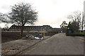
Access road, Henderson Hall, Red Hall Drive, Newcastle
An access road on Newcastle University's Henderson Hall site. A large student accommodation building stood on the bare earth to the left of the road, but has been demolished in recent months.
Image: © Graham Robson
Taken: 20 Mar 2020
0.15 miles
7
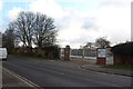
Newcastle University site entrance, Red Hall Drive, Newcastle
A gated entrance into Newcastle University's Henderson Hall site. A large student accommodation building stood on the other side of the boundary until its demolition in recent months.
Image: © Graham Robson
Taken: 20 Mar 2020
0.16 miles
8
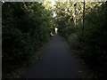
Public bridleway behind Stonecroft Gardens, High Heaton, Newcastle upon Tyne
A public bridleway surfaced with tarmace between the back gardens of Stonecroft Gardens and the boundary of a Newcastle University sports ground.
Image: © Graham Robson
Taken: 31 May 2020
0.17 miles
9
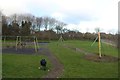
Play Park, Red Hall Drive, Newcastle
A tired looking, and empty, play park off Red Hall Drive.
Image: © Graham Robson
Taken: 20 Mar 2020
0.18 miles
10
Houses, Turbinia Gardens, High Heaton, Newcastle upon Tyne
A pair of houses at the southern end of Turbinia Gardens in High Heaton. All the houses on the street, and parallel streets are of the same age and style.
Image: © Graham Robson
Taken: 19 Jun 2020
0.19 miles