IMAGES TAKEN NEAR TO
Nunwick Way, NEWCASTLE UPON TYNE, NE7 7GB
Introduction
This page details the photographs taken nearby to Nunwick Way, NE7 7GB by members of the Geograph project.
The Geograph project started in 2005 with the aim of publishing, organising and preserving representative images for every square kilometre of Great Britain, Ireland and the Isle of Man.

There are currently over 7.5m images from over14,400 individuals and you can help contribute to the project by visiting https://www.geograph.org.uk
Image Map
Images are licensed for reuse under creativecommons.org/licenses/by-sa/2.0
Notes
- Clicking on the map will re-center to the selected point.
- The higher the marker number, the further away the image location is from the centre of the postcode.
Image Listing (12 Images Found)
Images are licensed for reuse under creativecommons.org/licenses/by-sa/2.0
Image
Details
Distance
1
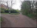
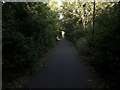
Bridleway north of Butterburn Close, Longbenton
A junction of bridleways north of the houses on Butterburn Close.
Image: © Graham Robson
Taken: 10 Apr 2020
0.05 miles
2
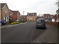
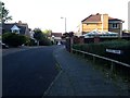
Roundstone Close, Longbenton
A street on a residential estate in the Longbenton area of North Tyneside.
Image: © Graham Robson
Taken: 10 Apr 2020
0.09 miles
3
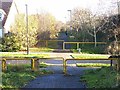
Cycleway crossing of Greenlee Drive
At the eastern end of the Coxlodge Waggonway, the cycle path diverges from the line of the old waggonway to follow paths through the housing estate down to the Coast Road.
Image: © Oliver Dixon
Taken: 4 Dec 2013
0.16 miles
4
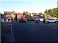
Detached houses, Cottage Farm, High Heaton, Newcastle upon Tyne
A small close of detached houses in High Heaton.
Image: © Graham Robson
Taken: 31 May 2020
0.17 miles
5
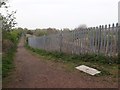
Bridleway beside the East Coast Mainline Railway
A bridleway separated from the East Coast Mainline Railway by a substantial palisade fence.
Image: © Graham Robson
Taken: 10 Apr 2020
0.19 miles
6
Cottage Farm, High Heaton, Newcastle upon Tyne
A residential close at the end of Meridian Way in High Heaton.
Image: © Graham Robson
Taken: 31 May 2020
0.19 miles
7
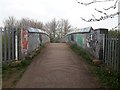
Footbridge crossing the East Coast Mainline
A footbridge carrying a bridleway across the tracks of the East Coast Mainline railway line in Longbenton.
Image: © Graham Robson
Taken: 10 Apr 2020
0.20 miles
8
Public bridleway behind Stonecroft Gardens, High Heaton, Newcastle upon Tyne
A public bridleway surfaced with tarmace between the back gardens of Stonecroft Gardens and the boundary of a Newcastle University sports ground.
Image: © Graham Robson
Taken: 31 May 2020
0.20 miles
9
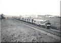
'Peak' Type 4 heads north with a fast goods train
Image: © Roger Cornfoot
Taken: Unknown
0.20 miles
10
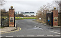
Entrance to Newcastle United Academy
The Newcastle United Academy is based in the eastern side of the city between the district of Longbenton and the separate town of Wallsend. The distant buildings belong to one of the Newcastle universities, probably the University of Northumbria.
Image: © Trevor Littlewood
Taken: 16 Mar 2016
0.22 miles