IMAGES TAKEN NEAR TO
Benton Road, NEWCASTLE UPON TYNE, NE7 7DS
Introduction
This page details the photographs taken nearby to Benton Road, NE7 7DS by members of the Geograph project.
The Geograph project started in 2005 with the aim of publishing, organising and preserving representative images for every square kilometre of Great Britain, Ireland and the Isle of Man.

There are currently over 7.5m images from over14,400 individuals and you can help contribute to the project by visiting https://www.geograph.org.uk
Image Map
Images are licensed for reuse under creativecommons.org/licenses/by-sa/2.0
Notes
- Clicking on the map will re-center to the selected point.
- The higher the marker number, the further away the image location is from the centre of the postcode.
Image Listing (21 Images Found)
Images are licensed for reuse under creativecommons.org/licenses/by-sa/2.0
Image
Details
Distance
1
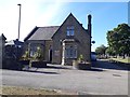
Gatehouse, Heaton Cemetery, Newcastle upon Tyne
A lodge beside the main entrance to Heaton Cemetery on Benton Road.
Image: © Graham Robson
Taken: 27 May 2020
0.02 miles
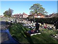
2
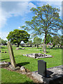
Gravestones in Heaton Cemetery
The monuments are to the north-east of the pair of chapels close to the cemetery entrance. Many older gravestones have been laid down, presumably through being unstable - there's one such near to the centre of the image. There's surely another insecure stone nearby!
Image: © Trevor Littlewood
Taken: 8 May 2018
0.07 miles
3

Byker and Heaton Cemetery
The cemetery from Benton Road.
Image: © Paul Robson
Taken: 26 Jun 2005
0.07 miles
4
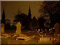
Heaton cemetery and churches
Looking in off Benton Road.
Image: © Stephen Sweeney
Taken: 15 Jan 2009
0.09 miles
5
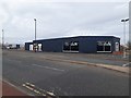
Former car dealership, Benton Road
A former Peugeot car dealer's premises located on Benton Road. The premises have been unoccupied since 2018.
Image: © Graham Robson
Taken: 3 Apr 2020
0.10 miles
6
Plaque, Coast Road, Newcastle upon Tyne
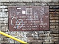
An inscribed stone plaque commemorating the official opening of the Coast Road or A1058 which was completed in 1967. The location of the stone can be seen beside the entrance to the subway under the road in Image
Image: © Graham Robson
Taken: 4 Jul 2020
0.12 miles
7
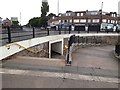
Pedestrian underpass, High Heaton, Newcastle upon Tyne
An underpass allowing pedestrians to safely navigate the busy junction of the Coast Road, Chillingham Road and Benton Road.
Image: © Graham Robson
Taken: 7 Jun 2020
0.12 miles
8
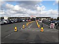
Socially distanced queuing space, Sainsbury's, Heaton
Cones have been deployed in the supermarket car park to reserve space for customers queuing waiting to access the large Sainsbury's Supermarket in the High Heaton part of Newcastle.
The COVID-19 infectious disease pandemic that affected the UK in the spring of 2020 meant that retailers were implementing several new (and hopefully temporary) procedures in an attempt to mitigate the risk of catching the disease for both shop workers and shoppers. These measures included limiting the number of people allowed in the store at any time and setting aside space in the car park to allow people to queue to get in to the shop in a way that complied with recommendations for people from different households to remain at least 2 metres apart.
Image: © Graham Robson
Taken: 17 Apr 2020
0.15 miles
9
Graves in Heaton Cemetery, Newcastle upon Tyne
The bare earth and plethora of adornments indicate that the burials in this area of Heaton Cemetery have been relatively recent.
Image: © Graham Robson
Taken: 21 Apr 2020
0.17 miles
10
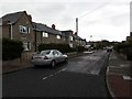
Plessey Terrace, High Heaton, Newcastle upon Tyne
A residential street in the High Heaton part of Newcastle. The area contains a mixture of semi detached and terraced houses.
Image: © Graham Robson
Taken: 1 May 2020
0.17 miles